You are here: Home > Network List > CI - Caltech Regional Seismic Network Stations List
> Station SHO Shoshone, CA, USA > Earthquake Result Viewer
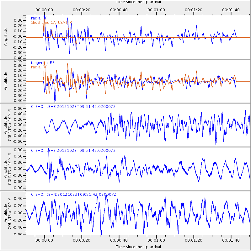
SHO Shoshone, CA, USA - Earthquake Result Viewer
*The percent match for this event was below the threshold and hence no stack was calculated.
| Earthquake location: |
Southeast Of Loyalty Islands |
| Earthquake latitude/longitude: |
-22.3/171.7 |
| Earthquake time(UTC): |
2012/10/23 (297) 09:39:30 GMT |
| Earthquake Depth: |
123 km |
| Earthquake Magnitude: |
5.9 MB, 5.8 MW, 5.9 MW |
| Earthquake Catalog/Contributor: |
WHDF/NEIC |
|
| Network: |
CI Caltech Regional Seismic Network |
| Station: |
SHO Shoshone, CA, USA |
| Lat/Lon: |
35.90 N/116.28 W |
| Elevation: |
451 m |
|
| Distance: |
89.3 deg |
| Az: |
50.567 deg |
| Baz: |
241.754 deg |
| Ray Param: |
$rayparam |
*The percent match for this event was below the threshold and hence was not used in the summary stack. |
|
| Radial Match: |
57.93012 % |
| Radial Bump: |
400 |
| Transverse Match: |
46.216026 % |
| Transverse Bump: |
400 |
| SOD ConfigId: |
478790 |
| Insert Time: |
2013-02-25 14:46:20.355 +0000 |
| GWidth: |
2.5 |
| Max Bumps: |
400 |
| Tol: |
0.001 |
|
Signal To Noise
| Channel | StoN | STA | LTA |
| CI:SHO: :BHZ:20121023T09:51:42.020007Z | 3.297223 | 3.4467186E-7 | 1.0453399E-7 |
| CI:SHO: :BHN:20121023T09:51:42.020007Z | 3.1787107 | 2.3415322E-7 | 7.366295E-8 |
| CI:SHO: :BHE:20121023T09:51:42.020007Z | 1.5045087 | 2.0574188E-7 | 1.3675022E-7 |
| Arrivals |
| Ps | |
| PpPs | |
| PsPs/PpSs | |


