You are here: Home > Network List > G - GEOSCOPE Stations List
> Station WUS Wushi, Xinjiang Uygur, China > Earthquake Result Viewer
WUS Wushi, Xinjiang Uygur, China - Earthquake Result Viewer
| Earthquake location: |
New Britain Region, P.N.G. |
| Earthquake latitude/longitude: |
-5.8/150.9 |
| Earthquake time(UTC): |
2000/02/06 (037) 11:33:52 GMT |
| Earthquake Depth: |
33 km |
| Earthquake Magnitude: |
6.6 MB, 6.8 MS, 6.6 MW, 6.3 ME |
| Earthquake Catalog/Contributor: |
WHDF/NEIC |
|
| Network: |
G GEOSCOPE |
| Station: |
WUS Wushi, Xinjiang Uygur, China |
| Lat/Lon: |
41.20 N/79.22 E |
| Elevation: |
1457 m |
|
| Distance: |
80.2 deg |
| Az: |
313.378 deg |
| Baz: |
106.613 deg |
| Ray Param: |
0.048381317 |
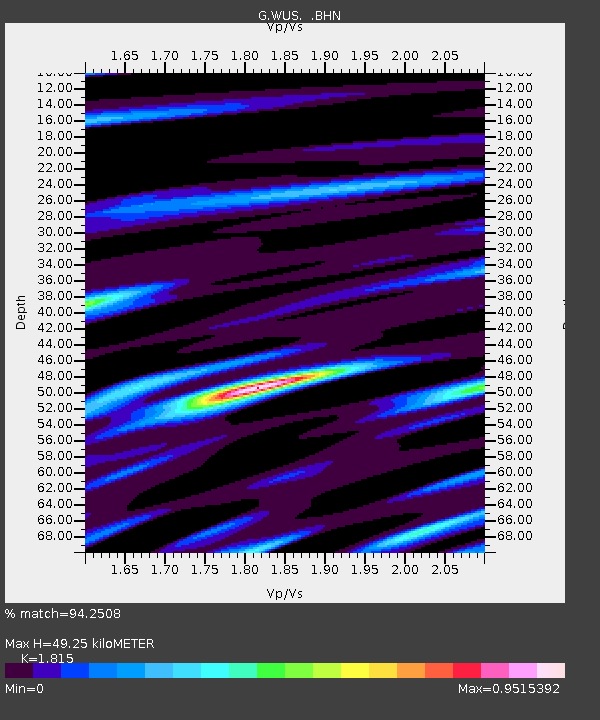
| Estimated Moho Depth: |
49.25 km |
| Estimated Crust Vp/Vs: |
1.82 |
| Assumed Crust Vp: |
6.353 km/s |
| Estimated Crust Vs: |
3.5 km/s |
| Estimated Crust Poisson's Ratio: |
0.28 |
|
| Radial Match: |
94.2508 % |
| Radial Bump: |
400 |
| Transverse Match: |
82.85762 % |
| Transverse Bump: |
400 |
| SOD ConfigId: |
3744 |
| Insert Time: |
2010-02-27 01:03:50.035 +0000 |
| GWidth: |
2.5 |
| Max Bumps: |
400 |
| Tol: |
0.001 |
|

Signal To Noise
| Channel | StoN | STA | LTA |
| G:WUS: :BHN:20000206T11:45:28.399019Z | 3.783364 | 2.14765E-7 | 5.6765614E-8 |
| G:WUS: :BHE:20000206T11:45:28.399019Z | 9.470694 | 5.004769E-7 | 5.2844797E-8 |
| G:WUS: :BHZ:20000206T11:45:28.399019Z | 20.37477 | 1.6417688E-6 | 8.057852E-8 |
| Arrivals |
| Ps | 6.5 SECOND |
| PpPs | 21 SECOND |
| PsPs/PpSs | 28 SECOND |


