You are here: Home > Network List > CI - Caltech Regional Seismic Network Stations List
> Station SMM Simmler, CA, USA > Earthquake Result Viewer
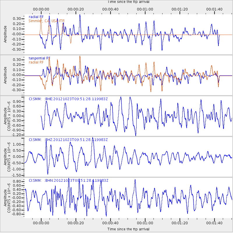
SMM Simmler, CA, USA - Earthquake Result Viewer
*The percent match for this event was below the threshold and hence no stack was calculated.
| Earthquake location: |
Southeast Of Loyalty Islands |
| Earthquake latitude/longitude: |
-22.3/171.7 |
| Earthquake time(UTC): |
2012/10/23 (297) 09:39:30 GMT |
| Earthquake Depth: |
123 km |
| Earthquake Magnitude: |
5.9 MB, 5.8 MW, 5.9 MW |
| Earthquake Catalog/Contributor: |
WHDF/NEIC |
|
| Network: |
CI Caltech Regional Seismic Network |
| Station: |
SMM Simmler, CA, USA |
| Lat/Lon: |
35.31 N/120.00 W |
| Elevation: |
599 m |
|
| Distance: |
86.4 deg |
| Az: |
49.59 deg |
| Baz: |
239.561 deg |
| Ray Param: |
$rayparam |
*The percent match for this event was below the threshold and hence was not used in the summary stack. |
|
| Radial Match: |
64.42724 % |
| Radial Bump: |
400 |
| Transverse Match: |
61.603344 % |
| Transverse Bump: |
400 |
| SOD ConfigId: |
478790 |
| Insert Time: |
2013-02-25 14:47:35.378 +0000 |
| GWidth: |
2.5 |
| Max Bumps: |
400 |
| Tol: |
0.001 |
|
Signal To Noise
| Channel | StoN | STA | LTA |
| CI:SMM: :BHZ:20121023T09:51:28.119983Z | 3.303287 | 6.139016E-7 | 1.8584568E-7 |
| CI:SMM: :BHN:20121023T09:51:28.119983Z | 0.7255859 | 2.724418E-7 | 3.7547835E-7 |
| CI:SMM: :BHE:20121023T09:51:28.119983Z | 0.9391555 | 3.5974725E-7 | 3.8305393E-7 |
| Arrivals |
| Ps | |
| PpPs | |
| PsPs/PpSs | |


