You are here: Home > Network List > CI - Caltech Regional Seismic Network Stations List
> Station MPP McPhearson Peak > Earthquake Result Viewer
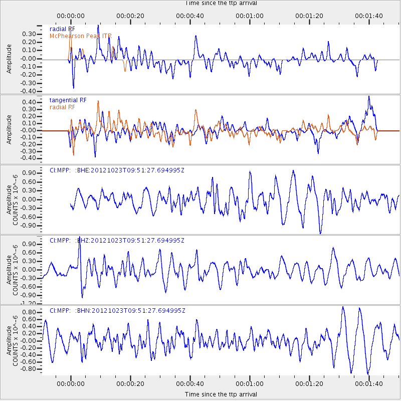
MPP McPhearson Peak - Earthquake Result Viewer
*The percent match for this event was below the threshold and hence no stack was calculated.
| Earthquake location: |
Southeast Of Loyalty Islands |
| Earthquake latitude/longitude: |
-22.3/171.7 |
| Earthquake time(UTC): |
2012/10/23 (297) 09:39:30 GMT |
| Earthquake Depth: |
123 km |
| Earthquake Magnitude: |
5.9 MB, 5.8 MW, 5.9 MW |
| Earthquake Catalog/Contributor: |
WHDF/NEIC |
|
| Network: |
CI Caltech Regional Seismic Network |
| Station: |
MPP McPhearson Peak |
| Lat/Lon: |
34.89 N/119.81 W |
| Elevation: |
1739 m |
|
| Distance: |
86.3 deg |
| Az: |
50.033 deg |
| Baz: |
239.693 deg |
| Ray Param: |
$rayparam |
*The percent match for this event was below the threshold and hence was not used in the summary stack. |
|
| Radial Match: |
46.01746 % |
| Radial Bump: |
400 |
| Transverse Match: |
48.4715 % |
| Transverse Bump: |
400 |
| SOD ConfigId: |
478790 |
| Insert Time: |
2013-02-25 14:48:13.451 +0000 |
| GWidth: |
2.5 |
| Max Bumps: |
400 |
| Tol: |
0.001 |
|
Signal To Noise
| Channel | StoN | STA | LTA |
| CI:MPP: :BHZ:20121023T09:51:27.694995Z | 1.9620318 | 4.983266E-7 | 2.5398495E-7 |
| CI:MPP: :BHN:20121023T09:51:27.694995Z | 0.7080423 | 2.2664317E-7 | 3.2009834E-7 |
| CI:MPP: :BHE:20121023T09:51:27.694995Z | 0.9876137 | 2.0481343E-7 | 2.0738214E-7 |
| Arrivals |
| Ps | |
| PpPs | |
| PsPs/PpSs | |


