You are here: Home > Network List > ZJ12 - Transantarctic Mountains Northern Network Stations List
> Station SHRD Lister Nunataks, Antarctica > Earthquake Result Viewer
SHRD Lister Nunataks, Antarctica - Earthquake Result Viewer
| Earthquake location: |
Vanuatu Islands |
| Earthquake latitude/longitude: |
-13.6/166.8 |
| Earthquake time(UTC): |
2014/06/19 (170) 10:17:58 GMT |
| Earthquake Depth: |
60 km |
| Earthquake Magnitude: |
6.4 MWP |
| Earthquake Catalog/Contributor: |
NEIC PDE/NEIC COMCAT |
|
| Network: |
ZJ Transantarctic Mountains Northern Network |
| Station: |
SHRD Lister Nunataks, Antarctica |
| Lat/Lon: |
73.40 S/160.50 E |
| Elevation: |
2457 m |
|
| Distance: |
59.9 deg |
| Az: |
182.098 deg |
| Baz: |
7.115 deg |
| Ray Param: |
0.061727826 |
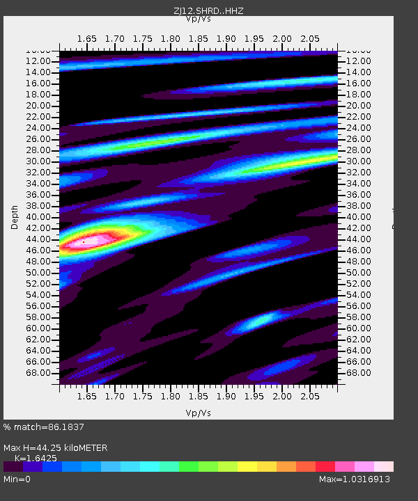
| Estimated Moho Depth: |
44.25 km |
| Estimated Crust Vp/Vs: |
1.64 |
| Assumed Crust Vp: |
6.264 km/s |
| Estimated Crust Vs: |
3.814 km/s |
| Estimated Crust Poisson's Ratio: |
0.21 |
|
| Radial Match: |
86.1837 % |
| Radial Bump: |
355 |
| Transverse Match: |
80.41196 % |
| Transverse Bump: |
399 |
| SOD ConfigId: |
3390531 |
| Insert Time: |
2019-04-12 08:32:44.887 +0000 |
| GWidth: |
2.5 |
| Max Bumps: |
400 |
| Tol: |
0.001 |
|

Signal To Noise
| Channel | StoN | STA | LTA |
| ZJ:SHRD: :HHZ:20140619T10:27:27.030Z | 6.861452 | 2.1607625E-6 | 3.149133E-7 |
| ZJ:SHRD: :HHN:20140619T10:27:27.030Z | 4.558327 | 1.246633E-6 | 2.7348474E-7 |
| ZJ:SHRD: :HHE:20140619T10:27:27.030Z | 1.2177675 | 4.7386177E-7 | 3.891234E-7 |
| Arrivals |
| Ps | 4.8 SECOND |
| PpPs | 18 SECOND |
| PsPs/PpSs | 23 SECOND |


