You are here: Home > Network List > G - GEOSCOPE Stations List
> Station WUS Wushi, Xinjiang Uygur, China > Earthquake Result Viewer
WUS Wushi, Xinjiang Uygur, China - Earthquake Result Viewer
| Earthquake location: |
Vanuatu Islands |
| Earthquake latitude/longitude: |
-15.4/166.9 |
| Earthquake time(UTC): |
2000/10/04 (278) 16:58:44 GMT |
| Earthquake Depth: |
23 km |
| Earthquake Magnitude: |
6.1 MB, 6.9 MS, 6.8 MW, 6.5 ME |
| Earthquake Catalog/Contributor: |
WHDF/NEIC |
|
| Network: |
G GEOSCOPE |
| Station: |
WUS Wushi, Xinjiang Uygur, China |
| Lat/Lon: |
41.20 N/79.22 E |
| Elevation: |
1457 m |
|
| Distance: |
98.3 deg |
| Az: |
310.363 deg |
| Baz: |
103.136 deg |
| Ray Param: |
0.039940935 |
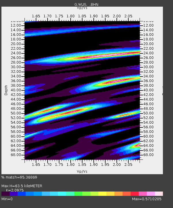
| Estimated Moho Depth: |
63.5 km |
| Estimated Crust Vp/Vs: |
2.10 |
| Assumed Crust Vp: |
6.353 km/s |
| Estimated Crust Vs: |
3.029 km/s |
| Estimated Crust Poisson's Ratio: |
0.35 |
|
| Radial Match: |
95.36869 % |
| Radial Bump: |
400 |
| Transverse Match: |
86.82356 % |
| Transverse Bump: |
400 |
| SOD ConfigId: |
3744 |
| Insert Time: |
2010-02-27 01:04:00.085 +0000 |
| GWidth: |
2.5 |
| Max Bumps: |
400 |
| Tol: |
0.001 |
|

Signal To Noise
| Channel | StoN | STA | LTA |
| G:WUS: :BHN:20001004T17:11:48.099001Z | 2.1868477 | 7.584854E-8 | 3.468396E-8 |
| G:WUS: :BHE:20001004T17:11:48.099001Z | 10.167601 | 2.4199724E-7 | 2.380082E-8 |
| G:WUS: :BHZ:20001004T17:11:48.099001Z | 14.428994 | 7.711103E-7 | 5.3441724E-8 |
| Arrivals |
| Ps | 11 SECOND |
| PpPs | 30 SECOND |
| PsPs/PpSs | 42 SECOND |


