You are here: Home > Network List > TA - USArray Transportable Network (new EarthScope stations) Stations List
> Station N02D Trinity Center, CA, USA > Earthquake Result Viewer
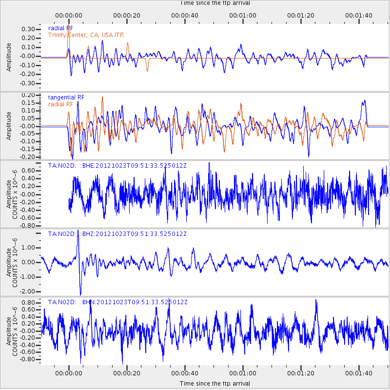
N02D Trinity Center, CA, USA - Earthquake Result Viewer
*The percent match for this event was below the threshold and hence no stack was calculated.
| Earthquake location: |
Southeast Of Loyalty Islands |
| Earthquake latitude/longitude: |
-22.3/171.7 |
| Earthquake time(UTC): |
2012/10/23 (297) 09:39:30 GMT |
| Earthquake Depth: |
123 km |
| Earthquake Magnitude: |
5.9 MB, 5.8 MW, 5.9 MW |
| Earthquake Catalog/Contributor: |
WHDF/NEIC |
|
| Network: |
TA USArray Transportable Network (new EarthScope stations) |
| Station: |
N02D Trinity Center, CA, USA |
| Lat/Lon: |
40.97 N/122.71 W |
| Elevation: |
937 m |
|
| Distance: |
87.5 deg |
| Az: |
43.647 deg |
| Baz: |
237.578 deg |
| Ray Param: |
$rayparam |
*The percent match for this event was below the threshold and hence was not used in the summary stack. |
|
| Radial Match: |
58.68131 % |
| Radial Bump: |
400 |
| Transverse Match: |
56.68175 % |
| Transverse Bump: |
395 |
| SOD ConfigId: |
478790 |
| Insert Time: |
2013-02-25 14:54:14.190 +0000 |
| GWidth: |
2.5 |
| Max Bumps: |
400 |
| Tol: |
0.001 |
|
Signal To Noise
| Channel | StoN | STA | LTA |
| TA:N02D: :BHZ:20121023T09:51:33.525012Z | 3.236566 | 9.061659E-7 | 2.7997757E-7 |
| TA:N02D: :BHN:20121023T09:51:33.525012Z | 1.0954384 | 3.1455843E-7 | 2.8715303E-7 |
| TA:N02D: :BHE:20121023T09:51:33.525012Z | 1.1164054 | 2.8191565E-7 | 2.5252086E-7 |
| Arrivals |
| Ps | |
| PpPs | |
| PsPs/PpSs | |


