You are here: Home > Network List > G - GEOSCOPE Stations List
> Station WUS Wushi, Xinjiang Uygur, China > Earthquake Result Viewer
WUS Wushi, Xinjiang Uygur, China - Earthquake Result Viewer
| Earthquake location: |
Near East Coast Of Honshu, Japan |
| Earthquake latitude/longitude: |
36.5/141.0 |
| Earthquake time(UTC): |
2000/07/20 (202) 18:39:18 GMT |
| Earthquake Depth: |
47 km |
| Earthquake Magnitude: |
6.1 MB, 5.4 MS, 6.1 ME, 6.0 MW |
| Earthquake Catalog/Contributor: |
WHDF/NEIC |
|
| Network: |
G GEOSCOPE |
| Station: |
WUS Wushi, Xinjiang Uygur, China |
| Lat/Lon: |
41.20 N/79.22 E |
| Elevation: |
1457 m |
|
| Distance: |
47.4 deg |
| Az: |
295.504 deg |
| Baz: |
74.494 deg |
| Ray Param: |
0.06986769 |
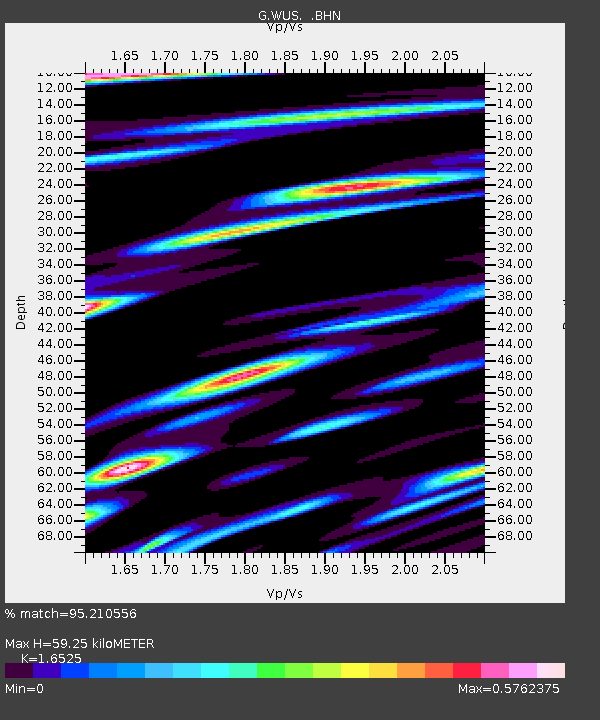
| Estimated Moho Depth: |
59.25 km |
| Estimated Crust Vp/Vs: |
1.65 |
| Assumed Crust Vp: |
6.353 km/s |
| Estimated Crust Vs: |
3.844 km/s |
| Estimated Crust Poisson's Ratio: |
0.21 |
|
| Radial Match: |
95.210556 % |
| Radial Bump: |
400 |
| Transverse Match: |
90.39116 % |
| Transverse Bump: |
400 |
| SOD ConfigId: |
3744 |
| Insert Time: |
2010-02-27 01:04:12.027 +0000 |
| GWidth: |
2.5 |
| Max Bumps: |
400 |
| Tol: |
0.001 |
|
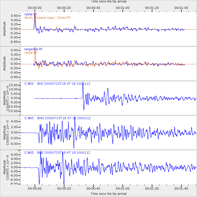
Signal To Noise
| Channel | StoN | STA | LTA |
| G:WUS: :BHN:20000720T18:47:18.300011Z | 22.005587 | 1.4743448E-6 | 6.699866E-8 |
| G:WUS: :BHE:20000720T18:47:18.300011Z | 61.17283 | 3.1908646E-6 | 5.2161468E-8 |
| G:WUS: :BHZ:20000720T18:47:18.300011Z | 200.90741 | 6.2428503E-6 | 3.107327E-8 |
| Arrivals |
| Ps | 6.5 SECOND |
| PpPs | 23 SECOND |
| PsPs/PpSs | 30 SECOND |


