You are here: Home > Network List > AZ - ANZA Regional Network Stations List
> Station SOL AZ.SOL > Earthquake Result Viewer
SOL AZ.SOL - Earthquake Result Viewer
| Earthquake location: |
Costa Rica |
| Earthquake latitude/longitude: |
10.1/-85.3 |
| Earthquake time(UTC): |
2012/10/24 (298) 00:45:32 GMT |
| Earthquake Depth: |
17 km |
| Earthquake Magnitude: |
6.0 MB, 6.2 MS, 6.5 MW, 6.4 MW |
| Earthquake Catalog/Contributor: |
WHDF/NEIC |
|
| Network: |
AZ ANZA Regional Network |
| Station: |
SOL AZ.SOL |
| Lat/Lon: |
32.84 N/117.25 W |
| Elevation: |
245 m |
|
| Distance: |
37.1 deg |
| Az: |
312.431 deg |
| Baz: |
120.301 deg |
| Ray Param: |
0.07628921 |
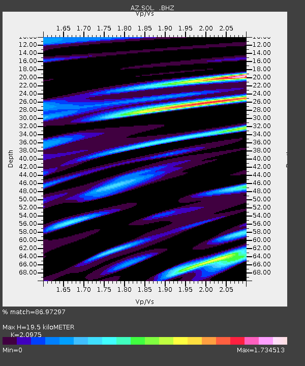
| Estimated Moho Depth: |
19.5 km |
| Estimated Crust Vp/Vs: |
2.10 |
| Assumed Crust Vp: |
6.264 km/s |
| Estimated Crust Vs: |
2.986 km/s |
| Estimated Crust Poisson's Ratio: |
0.35 |
|
| Radial Match: |
86.97297 % |
| Radial Bump: |
400 |
| Transverse Match: |
80.80059 % |
| Transverse Bump: |
400 |
| SOD ConfigId: |
478790 |
| Insert Time: |
2013-02-25 15:19:04.209 +0000 |
| GWidth: |
2.5 |
| Max Bumps: |
400 |
| Tol: |
0.001 |
|

Signal To Noise
| Channel | StoN | STA | LTA |
| AZ:SOL: :BHZ:20121024T00:52:11.819987Z | 6.9504533 | 3.3190088E-6 | 4.7752405E-7 |
| AZ:SOL: :BHN:20121024T00:52:11.819987Z | 1.8238941 | 1.2472287E-6 | 6.8382735E-7 |
| AZ:SOL: :BHE:20121024T00:52:11.819987Z | 3.367291 | 2.6682274E-6 | 7.9239584E-7 |
| Arrivals |
| Ps | 3.6 SECOND |
| PpPs | 9.1 SECOND |
| PsPs/PpSs | 13 SECOND |


