You are here: Home > Network List > AZ - ANZA Regional Network Stations List
> Station MONP2 Monument Peak TA Vault, Mt. Laguna, CA, USA > Earthquake Result Viewer
MONP2 Monument Peak TA Vault, Mt. Laguna, CA, USA - Earthquake Result Viewer

| Earthquake location: |
Costa Rica |
| Earthquake latitude/longitude: |
10.1/-85.3 |
| Earthquake time(UTC): |
2012/10/24 (298) 00:45:32 GMT |
| Earthquake Depth: |
17 km |
| Earthquake Magnitude: |
6.0 MB, 6.2 MS, 6.5 MW, 6.4 MW |
| Earthquake Catalog/Contributor: |
WHDF/NEIC |
|
| Network: |
AZ ANZA Regional Network |
| Station: |
MONP2 Monument Peak TA Vault, Mt. Laguna, CA, USA |
| Lat/Lon: |
32.89 N/116.42 W |
| Elevation: |
1000 m |
|
| Distance: |
36.6 deg |
| Az: |
313.097 deg |
| Baz: |
121.28 deg |
| Ray Param: |
0.076600134 |
| Estimated Moho Depth: |
31.25 km |
| Estimated Crust Vp/Vs: |
1.60 |
| Assumed Crust Vp: |
6.264 km/s |
| Estimated Crust Vs: |
3.915 km/s |
| Estimated Crust Poisson's Ratio: |
0.18 |
|
| Radial Match: |
91.73216 % |
| Radial Bump: |
370 |
| Transverse Match: |
79.46164 % |
| Transverse Bump: |
400 |
| SOD ConfigId: |
478790 |
| Insert Time: |
2013-02-25 15:19:16.638 +0000 |
| GWidth: |
2.5 |
| Max Bumps: |
400 |
| Tol: |
0.001 |
|
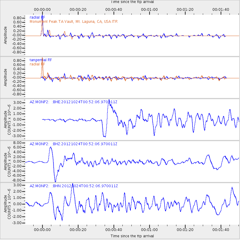
Signal To Noise
| Channel | StoN | STA | LTA |
| AZ:MONP2: :BHZ:20121024T00:52:06.970011Z | 15.984879 | 2.578552E-6 | 1.6131195E-7 |
| AZ:MONP2: :BHN:20121024T00:52:06.970011Z | 4.5492454 | 7.9606633E-7 | 1.7498866E-7 |
| AZ:MONP2: :BHE:20121024T00:52:06.970011Z | 10.509444 | 1.2018739E-6 | 1.1436132E-7 |
| Arrivals |
| Ps | 3.2 SECOND |
| PpPs | 12 SECOND |
| PsPs/PpSs | 15 SECOND |


