You are here: Home > Network List > CI - Caltech Regional Seismic Network Stations List
> Station ISA Isabella, Lake Isabella, CA, USA > Earthquake Result Viewer
ISA Isabella, Lake Isabella, CA, USA - Earthquake Result Viewer
| Earthquake location: |
Costa Rica |
| Earthquake latitude/longitude: |
10.1/-85.3 |
| Earthquake time(UTC): |
2012/10/24 (298) 00:45:32 GMT |
| Earthquake Depth: |
17 km |
| Earthquake Magnitude: |
6.0 MB, 6.2 MS, 6.5 MW, 6.4 MW |
| Earthquake Catalog/Contributor: |
WHDF/NEIC |
|
| Network: |
CI Caltech Regional Seismic Network |
| Station: |
ISA Isabella, Lake Isabella, CA, USA |
| Lat/Lon: |
35.66 N/118.47 W |
| Elevation: |
873 m |
|
| Distance: |
39.5 deg |
| Az: |
315.471 deg |
| Baz: |
122.0 deg |
| Ray Param: |
0.07495898 |
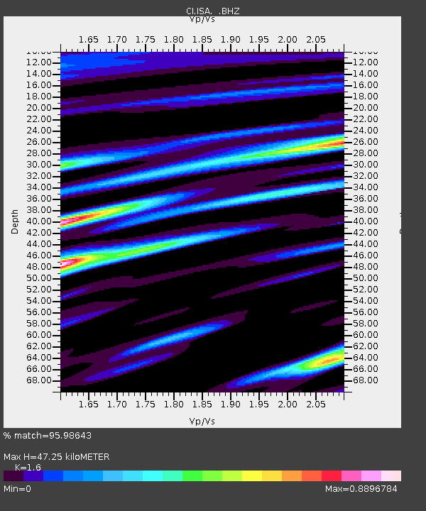
| Estimated Moho Depth: |
47.25 km |
| Estimated Crust Vp/Vs: |
1.60 |
| Assumed Crust Vp: |
6.1 km/s |
| Estimated Crust Vs: |
3.812 km/s |
| Estimated Crust Poisson's Ratio: |
0.18 |
|
| Radial Match: |
95.98643 % |
| Radial Bump: |
400 |
| Transverse Match: |
88.32781 % |
| Transverse Bump: |
400 |
| SOD ConfigId: |
478790 |
| Insert Time: |
2013-02-25 15:20:51.224 +0000 |
| GWidth: |
2.5 |
| Max Bumps: |
400 |
| Tol: |
0.001 |
|

Signal To Noise
| Channel | StoN | STA | LTA |
| CI:ISA: :BHZ:20121024T00:52:31.370005Z | 17.288933 | 2.6368061E-6 | 1.525141E-7 |
| CI:ISA: :BHN:20121024T00:52:31.370005Z | 18.658703 | 1.1124522E-6 | 5.9621094E-8 |
| CI:ISA: :BHE:20121024T00:52:31.370005Z | 6.9921618 | 6.319774E-7 | 9.038369E-8 |
| Arrivals |
| Ps | 5.0 SECOND |
| PpPs | 19 SECOND |
| PsPs/PpSs | 24 SECOND |


