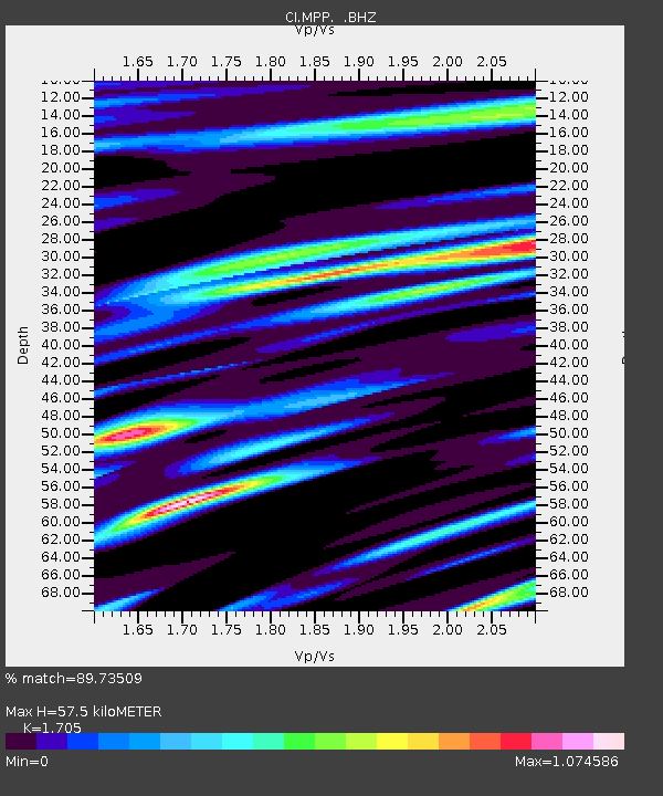
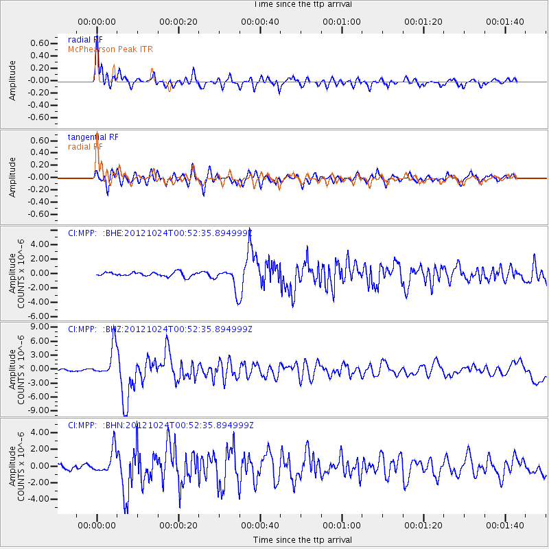
MPP McPhearson Peak - Earthquake Result Viewer

Earthquake location: Costa Rica
Earthquake latitude/longitude: 10.1/-85.3
Earthquake time(UTC): 2012/10/24 (298) 00:45:32 GMT
Earthquake Depth: 17 km
Earthquake Magnitude: 6.0 MB, 6.2 MS, 6.5 MW, 6.4 MW
Earthquake Catalog/Contributor: WHDF/NEIC
Network: CI Caltech Regional Seismic Network
Station: MPP McPhearson Peak
Lat/Lon: 34.89 N/119.81 W
Elevation: 1739 m
Distance: 40.0 deg
Az: 313.553 deg
Baz: 119.755 deg
Ray Param: 0.0746343
Estimated Moho Depth: 57.5 km
Estimated Crust Vp/Vs: 1.71
Assumed Crust Vp: 6.1 km/s
Estimated Crust Vs: 3.578 km/s
Estimated Crust Poisson's Ratio: 0.24
Radial Match: 89.73509 %
Radial Bump: 400
Transverse Match: 75.31288 %
Transverse Bump: 400
SOD ConfigId: 478790
Insert Time: 2013-02-25 15:23:41.326 +0000
GWidth: 2.5
Max Bumps: 400
Tol: 0.001

Signal To Noise

ChannelStoNSTALTA
CI:MPP: :BHZ:20121024T00:52:35.894999Z18.5317153.5234013E-61.9012819E-7
CI:MPP: :BHN:20121024T00:52:35.894999Z3.50763271.4972869E-64.2686537E-7
CI:MPP: :BHE:20121024T00:52:35.894999Z5.6324971.599613E-62.8399714E-7
Arrivals
Ps7.1 SECOND
PpPs24 SECOND
PsPs/PpSs31 SECOND