You are here: Home > Network List > TA - USArray Transportable Network (new EarthScope stations) Stations List
> Station 121A Cookes Peak, Deming, NM, USA > Earthquake Result Viewer
121A Cookes Peak, Deming, NM, USA - Earthquake Result Viewer
| Earthquake location: |
Costa Rica |
| Earthquake latitude/longitude: |
10.1/-85.3 |
| Earthquake time(UTC): |
2012/10/24 (298) 00:45:32 GMT |
| Earthquake Depth: |
17 km |
| Earthquake Magnitude: |
6.0 MB, 6.2 MS, 6.5 MW, 6.4 MW |
| Earthquake Catalog/Contributor: |
WHDF/NEIC |
|
| Network: |
TA USArray Transportable Network (new EarthScope stations) |
| Station: |
121A Cookes Peak, Deming, NM, USA |
| Lat/Lon: |
32.53 N/107.79 W |
| Elevation: |
1652 m |
|
| Distance: |
30.5 deg |
| Az: |
320.451 deg |
| Baz: |
132.073 deg |
| Ray Param: |
0.0793095 |
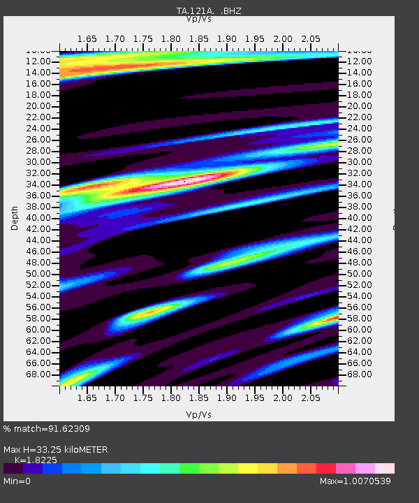
| Estimated Moho Depth: |
33.25 km |
| Estimated Crust Vp/Vs: |
1.82 |
| Assumed Crust Vp: |
6.502 km/s |
| Estimated Crust Vs: |
3.567 km/s |
| Estimated Crust Poisson's Ratio: |
0.28 |
|
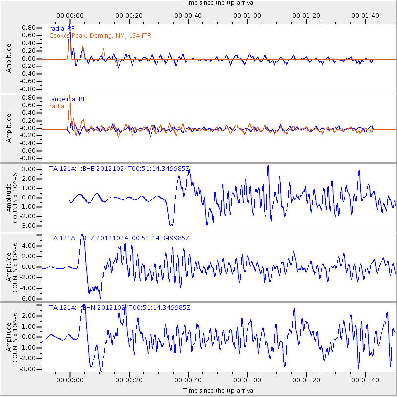
| Radial Match: |
91.62309 % |
| Radial Bump: |
400 |
| Transverse Match: |
77.64557 % |
| Transverse Bump: |
400 |
| SOD ConfigId: |
478790 |
| Insert Time: |
2013-02-25 15:33:32.955 +0000 |
| GWidth: |
2.5 |
| Max Bumps: |
400 |
| Tol: |
0.001 |
|
Signal To Noise
| Channel | StoN | STA | LTA |
| TA:121A: :BHZ:20121024T00:51:14.349985Z | 19.533985 | 2.9712535E-6 | 1.5210688E-7 |
| TA:121A: :BHN:20121024T00:51:14.349985Z | 5.328263 | 1.3910568E-6 | 2.6107136E-7 |
| TA:121A: :BHE:20121024T00:51:14.349985Z | 5.6677604 | 1.4495067E-6 | 2.5574593E-7 |
| Arrivals |
| Ps | 4.6 SECOND |
| PpPs | 13 SECOND |
| PsPs/PpSs | 18 SECOND |


