You are here: Home > Network List > TA - USArray Transportable Network (new EarthScope stations) Stations List
> Station K22A Casper, WY, USA > Earthquake Result Viewer
K22A Casper, WY, USA - Earthquake Result Viewer
| Earthquake location: |
Costa Rica |
| Earthquake latitude/longitude: |
10.1/-85.3 |
| Earthquake time(UTC): |
2012/10/24 (298) 00:45:32 GMT |
| Earthquake Depth: |
17 km |
| Earthquake Magnitude: |
6.0 MB, 6.2 MS, 6.5 MW, 6.4 MW |
| Earthquake Catalog/Contributor: |
WHDF/NEIC |
|
| Network: |
TA USArray Transportable Network (new EarthScope stations) |
| Station: |
K22A Casper, WY, USA |
| Lat/Lon: |
42.65 N/106.52 W |
| Elevation: |
1686 m |
|
| Distance: |
37.4 deg |
| Az: |
333.895 deg |
| Baz: |
144.033 deg |
| Ray Param: |
0.07615302 |
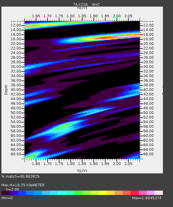
| Estimated Moho Depth: |
16.25 km |
| Estimated Crust Vp/Vs: |
2.08 |
| Assumed Crust Vp: |
6.178 km/s |
| Estimated Crust Vs: |
2.97 km/s |
| Estimated Crust Poisson's Ratio: |
0.35 |
|
| Radial Match: |
88.983925 % |
| Radial Bump: |
372 |
| Transverse Match: |
64.74823 % |
| Transverse Bump: |
400 |
| SOD ConfigId: |
478790 |
| Insert Time: |
2013-02-25 15:33:57.166 +0000 |
| GWidth: |
2.5 |
| Max Bumps: |
400 |
| Tol: |
0.001 |
|

Signal To Noise
| Channel | StoN | STA | LTA |
| TA:K22A: :BHZ:20121024T00:52:13.924998Z | 6.595775 | 2.2936733E-6 | 3.4774885E-7 |
| TA:K22A: :BHN:20121024T00:52:13.924998Z | 2.1690826 | 1.3298751E-6 | 6.131049E-7 |
| TA:K22A: :BHE:20121024T00:52:13.924998Z | 1.4807122 | 6.9488357E-7 | 4.6929011E-7 |
| Arrivals |
| Ps | 3.0 SECOND |
| PpPs | 7.6 SECOND |
| PsPs/PpSs | 11 SECOND |


