You are here: Home > Network List > TA - USArray Transportable Network (new EarthScope stations) Stations List
> Station M54A Oil Creek State Park, Oil City, PA, USA > Earthquake Result Viewer
M54A Oil Creek State Park, Oil City, PA, USA - Earthquake Result Viewer
| Earthquake location: |
Costa Rica |
| Earthquake latitude/longitude: |
10.1/-85.3 |
| Earthquake time(UTC): |
2012/10/24 (298) 00:45:32 GMT |
| Earthquake Depth: |
17 km |
| Earthquake Magnitude: |
6.0 MB, 6.2 MS, 6.5 MW, 6.4 MW |
| Earthquake Catalog/Contributor: |
WHDF/NEIC |
|
| Network: |
TA USArray Transportable Network (new EarthScope stations) |
| Station: |
M54A Oil Creek State Park, Oil City, PA, USA |
| Lat/Lon: |
41.51 N/79.66 W |
| Elevation: |
488 m |
|
| Distance: |
31.7 deg |
| Az: |
8.068 deg |
| Baz: |
190.604 deg |
| Ray Param: |
0.07895644 |
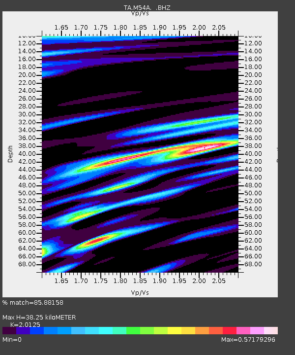
| Estimated Moho Depth: |
38.25 km |
| Estimated Crust Vp/Vs: |
2.01 |
| Assumed Crust Vp: |
6.121 km/s |
| Estimated Crust Vs: |
3.041 km/s |
| Estimated Crust Poisson's Ratio: |
0.34 |
|
| Radial Match: |
85.88158 % |
| Radial Bump: |
261 |
| Transverse Match: |
56.85936 % |
| Transverse Bump: |
314 |
| SOD ConfigId: |
478790 |
| Insert Time: |
2013-02-25 15:36:23.770 +0000 |
| GWidth: |
2.5 |
| Max Bumps: |
400 |
| Tol: |
0.001 |
|

Signal To Noise
| Channel | StoN | STA | LTA |
| TA:M54A: :BHZ:20121024T00:51:24.900004Z | 3.3085456 | 2.7966944E-6 | 8.4529427E-7 |
| TA:M54A: :BHN:20121024T00:51:24.900004Z | 2.7257836 | 1.9129884E-6 | 7.0181227E-7 |
| TA:M54A: :BHE:20121024T00:51:24.900004Z | 0.71243685 | 5.131302E-7 | 7.2024653E-7 |
| Arrivals |
| Ps | 6.7 SECOND |
| PpPs | 18 SECOND |
| PsPs/PpSs | 24 SECOND |


