You are here: Home > Network List > TA - USArray Transportable Network (new EarthScope stations) Stations List
> Station L39A Vinton, IA, USA > Earthquake Result Viewer
L39A Vinton, IA, USA - Earthquake Result Viewer
| Earthquake location: |
Costa Rica |
| Earthquake latitude/longitude: |
10.1/-85.3 |
| Earthquake time(UTC): |
2012/10/24 (298) 00:45:32 GMT |
| Earthquake Depth: |
17 km |
| Earthquake Magnitude: |
6.0 MB, 6.2 MS, 6.5 MW, 6.4 MW |
| Earthquake Catalog/Contributor: |
WHDF/NEIC |
|
| Network: |
TA USArray Transportable Network (new EarthScope stations) |
| Station: |
L39A Vinton, IA, USA |
| Lat/Lon: |
42.12 N/92.00 W |
| Elevation: |
261 m |
|
| Distance: |
32.5 deg |
| Az: |
350.687 deg |
| Baz: |
167.631 deg |
| Ray Param: |
0.078632504 |
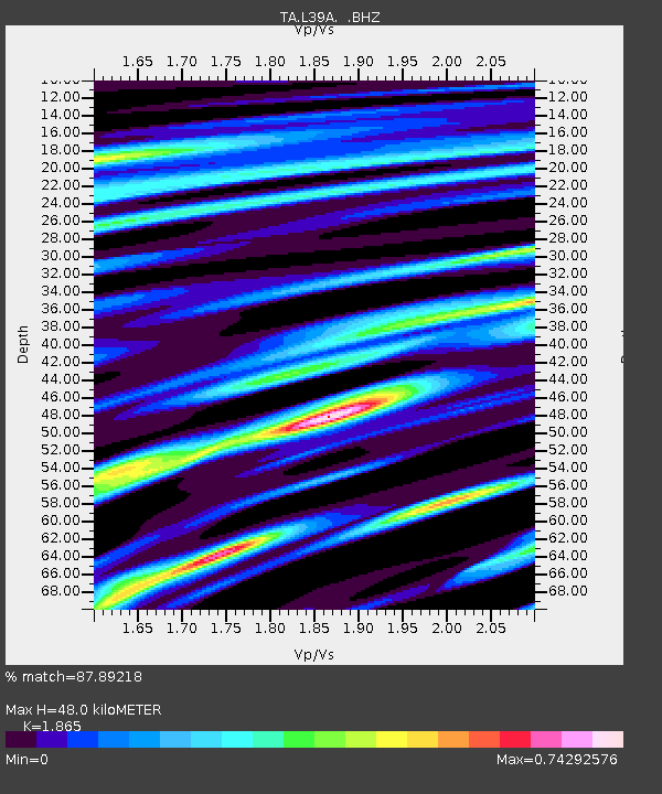
| Estimated Moho Depth: |
48.0 km |
| Estimated Crust Vp/Vs: |
1.87 |
| Assumed Crust Vp: |
6.53 km/s |
| Estimated Crust Vs: |
3.502 km/s |
| Estimated Crust Poisson's Ratio: |
0.30 |
|
| Radial Match: |
87.89218 % |
| Radial Bump: |
400 |
| Transverse Match: |
66.33792 % |
| Transverse Bump: |
400 |
| SOD ConfigId: |
478790 |
| Insert Time: |
2013-02-25 15:37:11.099 +0000 |
| GWidth: |
2.5 |
| Max Bumps: |
400 |
| Tol: |
0.001 |
|
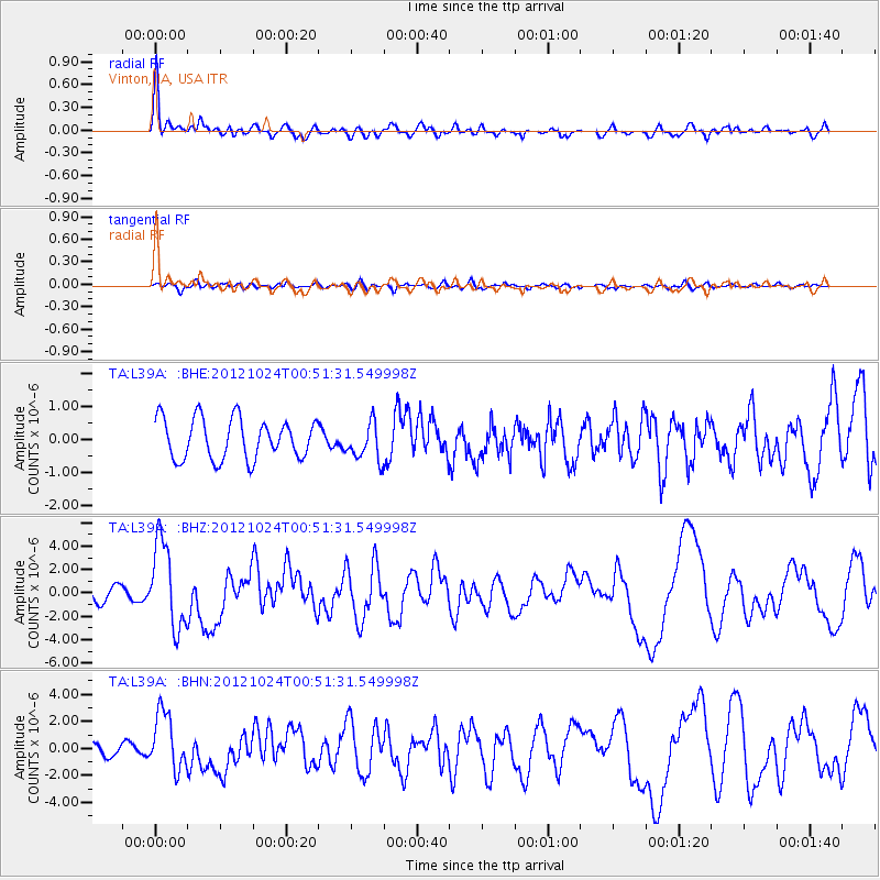
Signal To Noise
| Channel | StoN | STA | LTA |
| TA:L39A: :BHZ:20121024T00:51:31.549998Z | 5.5303802 | 3.6482108E-6 | 6.5966725E-7 |
| TA:L39A: :BHN:20121024T00:51:31.549998Z | 4.0804296 | 2.1237195E-6 | 5.2046465E-7 |
| TA:L39A: :BHE:20121024T00:51:31.549998Z | 0.92007846 | 5.57467E-7 | 6.0589076E-7 |
| Arrivals |
| Ps | 6.9 SECOND |
| PpPs | 19 SECOND |
| PsPs/PpSs | 26 SECOND |


