You are here: Home > Network List > TA - USArray Transportable Network (new EarthScope stations) Stations List
> Station L40A Anamosa, IA, USA > Earthquake Result Viewer
L40A Anamosa, IA, USA - Earthquake Result Viewer
| Earthquake location: |
Costa Rica |
| Earthquake latitude/longitude: |
10.1/-85.3 |
| Earthquake time(UTC): |
2012/10/24 (298) 00:45:32 GMT |
| Earthquake Depth: |
17 km |
| Earthquake Magnitude: |
6.0 MB, 6.2 MS, 6.5 MW, 6.4 MW |
| Earthquake Catalog/Contributor: |
WHDF/NEIC |
|
| Network: |
TA USArray Transportable Network (new EarthScope stations) |
| Station: |
L40A Anamosa, IA, USA |
| Lat/Lon: |
42.06 N/91.22 W |
| Elevation: |
242 m |
|
| Distance: |
32.3 deg |
| Az: |
351.725 deg |
| Baz: |
169.028 deg |
| Ray Param: |
0.078707576 |
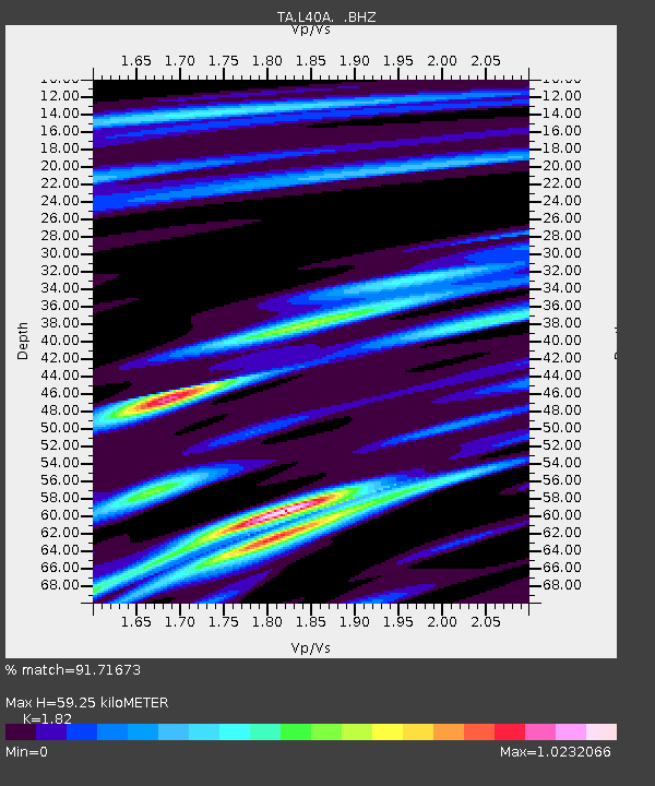
| Estimated Moho Depth: |
59.25 km |
| Estimated Crust Vp/Vs: |
1.82 |
| Assumed Crust Vp: |
6.53 km/s |
| Estimated Crust Vs: |
3.588 km/s |
| Estimated Crust Poisson's Ratio: |
0.28 |
|
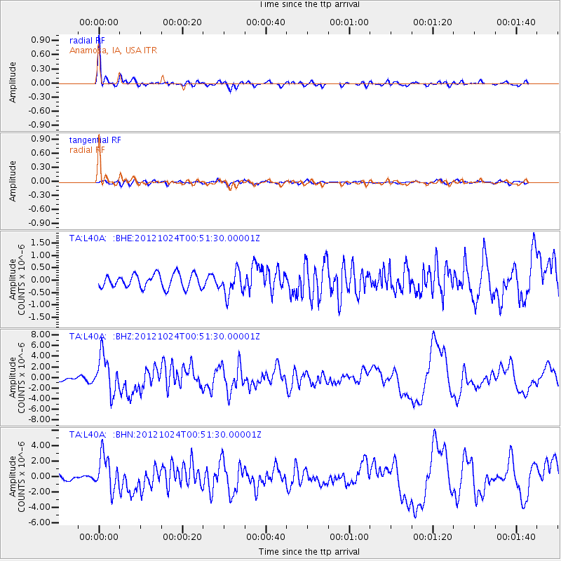
| Radial Match: |
91.71673 % |
| Radial Bump: |
344 |
| Transverse Match: |
58.27222 % |
| Transverse Bump: |
400 |
| SOD ConfigId: |
478790 |
| Insert Time: |
2013-02-25 15:37:32.182 +0000 |
| GWidth: |
2.5 |
| Max Bumps: |
400 |
| Tol: |
0.001 |
|
Signal To Noise
| Channel | StoN | STA | LTA |
| TA:L40A: :BHZ:20121024T00:51:30.00001Z | 7.11843 | 3.608995E-6 | 5.069931E-7 |
| TA:L40A: :BHN:20121024T00:51:30.00001Z | 4.579388 | 2.2740967E-6 | 4.9659405E-7 |
| TA:L40A: :BHE:20121024T00:51:30.00001Z | 1.7837787 | 4.964589E-7 | 2.7831868E-7 |
| Arrivals |
| Ps | 8.1 SECOND |
| PpPs | 24 SECOND |
| PsPs/PpSs | 32 SECOND |


