You are here: Home > Network List > TA - USArray Transportable Network (new EarthScope stations) Stations List
> Station M41A Milan, IL, USA > Earthquake Result Viewer
M41A Milan, IL, USA - Earthquake Result Viewer
| Earthquake location: |
Costa Rica |
| Earthquake latitude/longitude: |
10.1/-85.3 |
| Earthquake time(UTC): |
2012/10/24 (298) 00:45:32 GMT |
| Earthquake Depth: |
17 km |
| Earthquake Magnitude: |
6.0 MB, 6.2 MS, 6.5 MW, 6.4 MW |
| Earthquake Catalog/Contributor: |
WHDF/NEIC |
|
| Network: |
TA USArray Transportable Network (new EarthScope stations) |
| Station: |
M41A Milan, IL, USA |
| Lat/Lon: |
41.38 N/90.54 W |
| Elevation: |
226 m |
|
| Distance: |
31.5 deg |
| Az: |
352.436 deg |
| Baz: |
170.082 deg |
| Ray Param: |
0.07903415 |
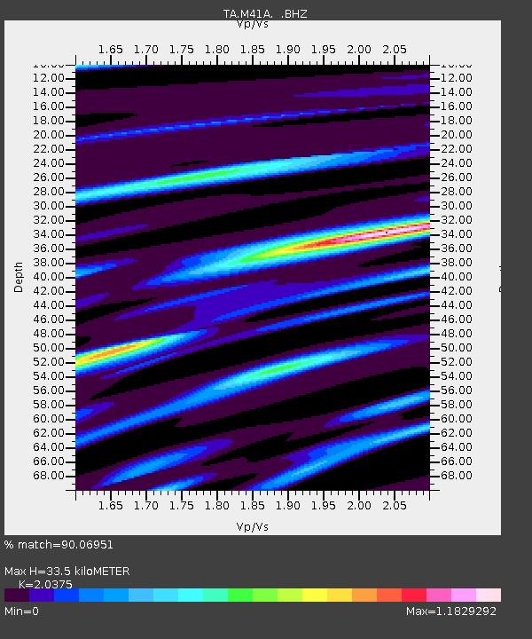
| Estimated Moho Depth: |
33.5 km |
| Estimated Crust Vp/Vs: |
2.04 |
| Assumed Crust Vp: |
6.498 km/s |
| Estimated Crust Vs: |
3.189 km/s |
| Estimated Crust Poisson's Ratio: |
0.34 |
|
| Radial Match: |
90.06951 % |
| Radial Bump: |
284 |
| Transverse Match: |
63.393578 % |
| Transverse Bump: |
400 |
| SOD ConfigId: |
478790 |
| Insert Time: |
2013-02-25 15:37:51.226 +0000 |
| GWidth: |
2.5 |
| Max Bumps: |
400 |
| Tol: |
0.001 |
|
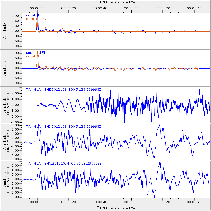
Signal To Noise
| Channel | StoN | STA | LTA |
| TA:M41A: :BHZ:20121024T00:51:23.299998Z | 10.456685 | 3.7867276E-6 | 3.621346E-7 |
| TA:M41A: :BHN:20121024T00:51:23.299998Z | 6.619505 | 2.4663932E-6 | 3.7259483E-7 |
| TA:M41A: :BHE:20121024T00:51:23.299998Z | 1.3955772 | 6.7072654E-7 | 4.806087E-7 |
| Arrivals |
| Ps | 5.7 SECOND |
| PpPs | 15 SECOND |
| PsPs/PpSs | 20 SECOND |


