You are here: Home > Network List > TA - USArray Transportable Network (new EarthScope stations) Stations List
> Station H40A Chili, WI, USA > Earthquake Result Viewer
H40A Chili, WI, USA - Earthquake Result Viewer
| Earthquake location: |
Costa Rica |
| Earthquake latitude/longitude: |
10.1/-85.3 |
| Earthquake time(UTC): |
2012/10/24 (298) 00:45:32 GMT |
| Earthquake Depth: |
17 km |
| Earthquake Magnitude: |
6.0 MB, 6.2 MS, 6.5 MW, 6.4 MW |
| Earthquake Catalog/Contributor: |
WHDF/NEIC |
|
| Network: |
TA USArray Transportable Network (new EarthScope stations) |
| Station: |
H40A Chili, WI, USA |
| Lat/Lon: |
44.62 N/90.39 W |
| Elevation: |
372 m |
|
| Distance: |
34.7 deg |
| Az: |
353.605 deg |
| Baz: |
171.165 deg |
| Ray Param: |
0.07759481 |
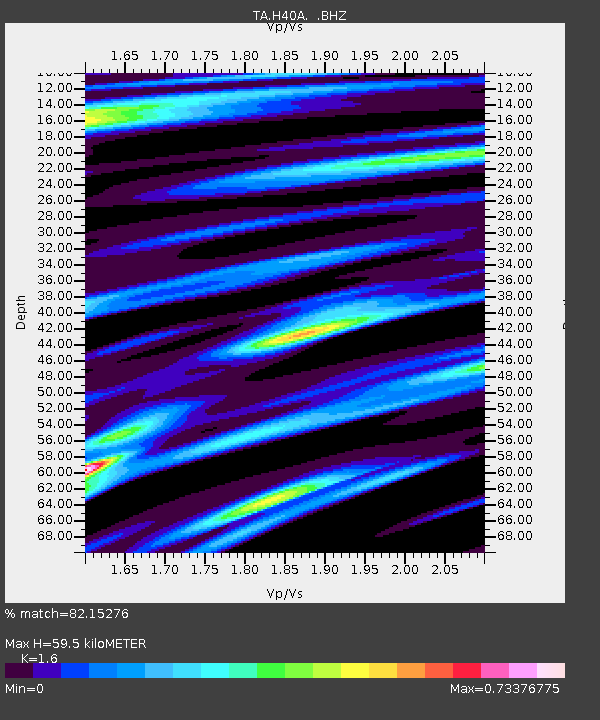
| Estimated Moho Depth: |
59.5 km |
| Estimated Crust Vp/Vs: |
1.60 |
| Assumed Crust Vp: |
6.571 km/s |
| Estimated Crust Vs: |
4.107 km/s |
| Estimated Crust Poisson's Ratio: |
0.18 |
|
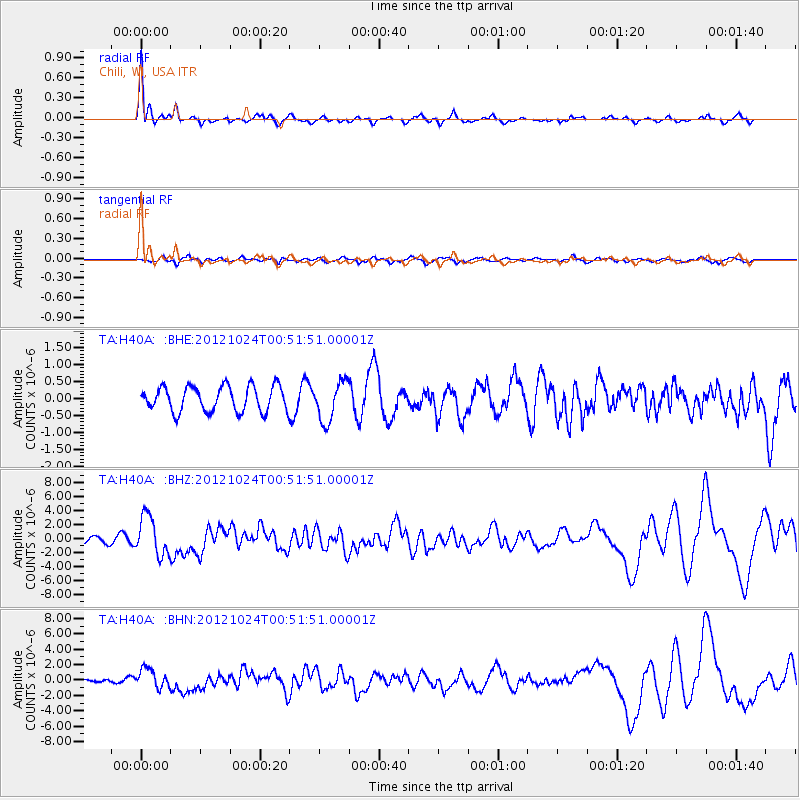
| Radial Match: |
82.15276 % |
| Radial Bump: |
310 |
| Transverse Match: |
59.106155 % |
| Transverse Bump: |
400 |
| SOD ConfigId: |
478790 |
| Insert Time: |
2013-02-25 15:38:04.693 +0000 |
| GWidth: |
2.5 |
| Max Bumps: |
400 |
| Tol: |
0.001 |
|
Signal To Noise
| Channel | StoN | STA | LTA |
| TA:H40A: :BHZ:20121024T00:51:51.00001Z | 5.894768 | 2.8032603E-6 | 4.7555056E-7 |
| TA:H40A: :BHN:20121024T00:51:51.00001Z | 4.971132 | 1.2504555E-6 | 2.5154344E-7 |
| TA:H40A: :BHE:20121024T00:51:51.00001Z | 1.581515 | 5.834965E-7 | 3.6894784E-7 |
| Arrivals |
| Ps | 5.9 SECOND |
| PpPs | 22 SECOND |
| PsPs/PpSs | 27 SECOND |


