You are here: Home > Network List > TA - USArray Transportable Network (new EarthScope stations) Stations List
> Station D41A Chassel, MI, USA > Earthquake Result Viewer
D41A Chassel, MI, USA - Earthquake Result Viewer
| Earthquake location: |
Costa Rica |
| Earthquake latitude/longitude: |
10.1/-85.3 |
| Earthquake time(UTC): |
2012/10/24 (298) 00:45:32 GMT |
| Earthquake Depth: |
17 km |
| Earthquake Magnitude: |
6.0 MB, 6.2 MS, 6.5 MW, 6.4 MW |
| Earthquake Catalog/Contributor: |
WHDF/NEIC |
|
| Network: |
TA USArray Transportable Network (new EarthScope stations) |
| Station: |
D41A Chassel, MI, USA |
| Lat/Lon: |
47.06 N/88.57 W |
| Elevation: |
271 m |
|
| Distance: |
37.0 deg |
| Az: |
356.283 deg |
| Baz: |
174.642 deg |
| Ray Param: |
0.07638299 |
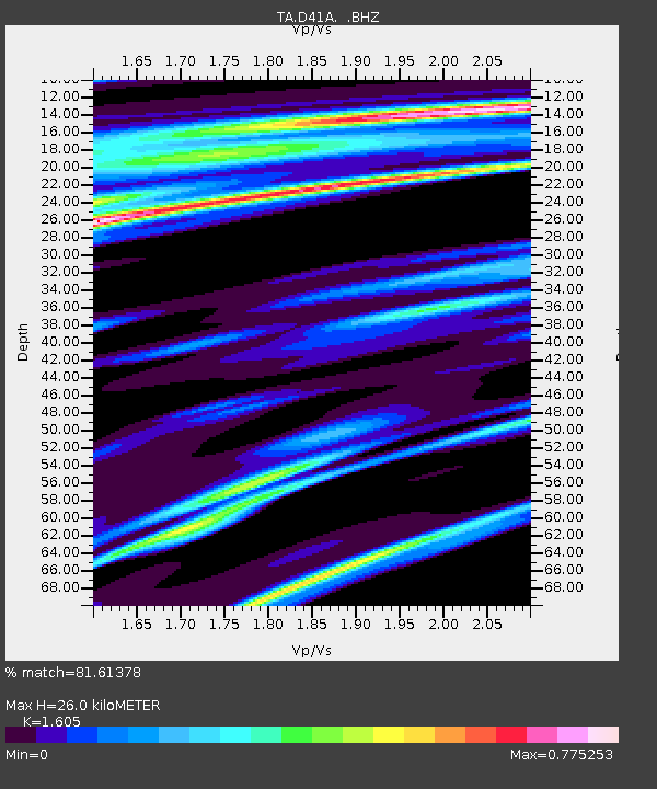
| Estimated Moho Depth: |
26.0 km |
| Estimated Crust Vp/Vs: |
1.61 |
| Assumed Crust Vp: |
6.467 km/s |
| Estimated Crust Vs: |
4.029 km/s |
| Estimated Crust Poisson's Ratio: |
0.18 |
|
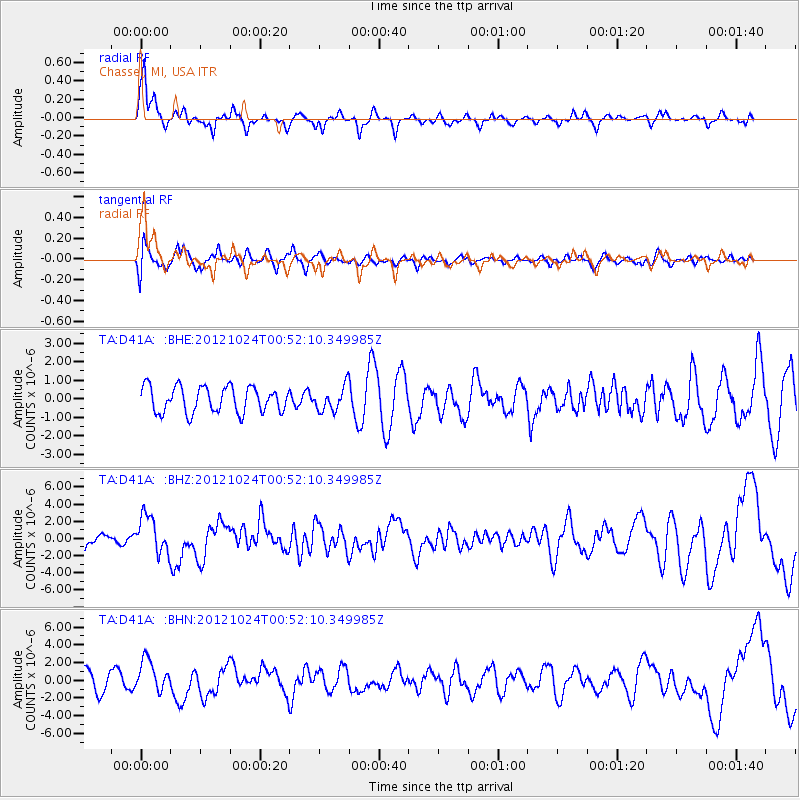
| Radial Match: |
81.61378 % |
| Radial Bump: |
348 |
| Transverse Match: |
58.931164 % |
| Transverse Bump: |
400 |
| SOD ConfigId: |
478790 |
| Insert Time: |
2013-02-25 15:40:24.315 +0000 |
| GWidth: |
2.5 |
| Max Bumps: |
400 |
| Tol: |
0.001 |
|
Signal To Noise
| Channel | StoN | STA | LTA |
| TA:D41A: :BHZ:20121024T00:52:10.349985Z | 2.579162 | 2.1843005E-6 | 8.4690316E-7 |
| TA:D41A: :BHN:20121024T00:52:10.349985Z | 1.7407438 | 1.7931667E-6 | 1.0301153E-6 |
| TA:D41A: :BHE:20121024T00:52:10.349985Z | 0.9456346 | 6.555262E-7 | 6.9321305E-7 |
| Arrivals |
| Ps | 2.6 SECOND |
| PpPs | 9.6 SECOND |
| PsPs/PpSs | 12 SECOND |


