You are here: Home > Network List > TA - USArray Transportable Network (new EarthScope stations) Stations List
> Station L43A Garden Prairie, IL, USA > Earthquake Result Viewer
L43A Garden Prairie, IL, USA - Earthquake Result Viewer
| Earthquake location: |
Costa Rica |
| Earthquake latitude/longitude: |
10.1/-85.3 |
| Earthquake time(UTC): |
2012/10/24 (298) 00:45:32 GMT |
| Earthquake Depth: |
17 km |
| Earthquake Magnitude: |
6.0 MB, 6.2 MS, 6.5 MW, 6.4 MW |
| Earthquake Catalog/Contributor: |
WHDF/NEIC |
|
| Network: |
TA USArray Transportable Network (new EarthScope stations) |
| Station: |
L43A Garden Prairie, IL, USA |
| Lat/Lon: |
42.18 N/88.74 W |
| Elevation: |
266 m |
|
| Distance: |
32.1 deg |
| Az: |
355.182 deg |
| Baz: |
173.611 deg |
| Ray Param: |
0.07877537 |
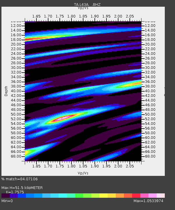
| Estimated Moho Depth: |
51.5 km |
| Estimated Crust Vp/Vs: |
1.76 |
| Assumed Crust Vp: |
6.571 km/s |
| Estimated Crust Vs: |
3.739 km/s |
| Estimated Crust Poisson's Ratio: |
0.26 |
|
| Radial Match: |
84.07106 % |
| Radial Bump: |
400 |
| Transverse Match: |
68.6383 % |
| Transverse Bump: |
400 |
| SOD ConfigId: |
478790 |
| Insert Time: |
2013-02-25 15:40:39.870 +0000 |
| GWidth: |
2.5 |
| Max Bumps: |
400 |
| Tol: |
0.001 |
|

Signal To Noise
| Channel | StoN | STA | LTA |
| TA:L43A: :BHZ:20121024T00:51:28.62501Z | 4.4317713 | 2.9573814E-6 | 6.673136E-7 |
| TA:L43A: :BHN:20121024T00:51:28.62501Z | 3.194643 | 2.0834768E-6 | 6.5217824E-7 |
| TA:L43A: :BHE:20121024T00:51:28.62501Z | 0.8075694 | 4.080397E-7 | 5.0526893E-7 |
| Arrivals |
| Ps | 6.5 SECOND |
| PpPs | 20 SECOND |
| PsPs/PpSs | 26 SECOND |


