You are here: Home > Network List > TA - USArray Transportable Network (new EarthScope stations) Stations List
> Station O44A Mansfield, IL, USA > Earthquake Result Viewer
O44A Mansfield, IL, USA - Earthquake Result Viewer
| Earthquake location: |
Costa Rica |
| Earthquake latitude/longitude: |
10.1/-85.3 |
| Earthquake time(UTC): |
2012/10/24 (298) 00:45:32 GMT |
| Earthquake Depth: |
17 km |
| Earthquake Magnitude: |
6.0 MB, 6.2 MS, 6.5 MW, 6.4 MW |
| Earthquake Catalog/Contributor: |
WHDF/NEIC |
|
| Network: |
TA USArray Transportable Network (new EarthScope stations) |
| Station: |
O44A Mansfield, IL, USA |
| Lat/Lon: |
40.15 N/88.47 W |
| Elevation: |
213 m |
|
| Distance: |
30.1 deg |
| Az: |
355.15 deg |
| Baz: |
173.764 deg |
| Ray Param: |
0.079418704 |
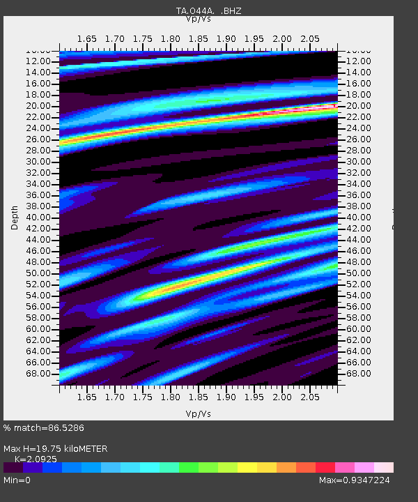
| Estimated Moho Depth: |
19.75 km |
| Estimated Crust Vp/Vs: |
2.09 |
| Assumed Crust Vp: |
6.498 km/s |
| Estimated Crust Vs: |
3.105 km/s |
| Estimated Crust Poisson's Ratio: |
0.35 |
|
| Radial Match: |
86.5286 % |
| Radial Bump: |
400 |
| Transverse Match: |
62.311157 % |
| Transverse Bump: |
400 |
| SOD ConfigId: |
478790 |
| Insert Time: |
2013-02-25 15:42:05.100 +0000 |
| GWidth: |
2.5 |
| Max Bumps: |
400 |
| Tol: |
0.001 |
|
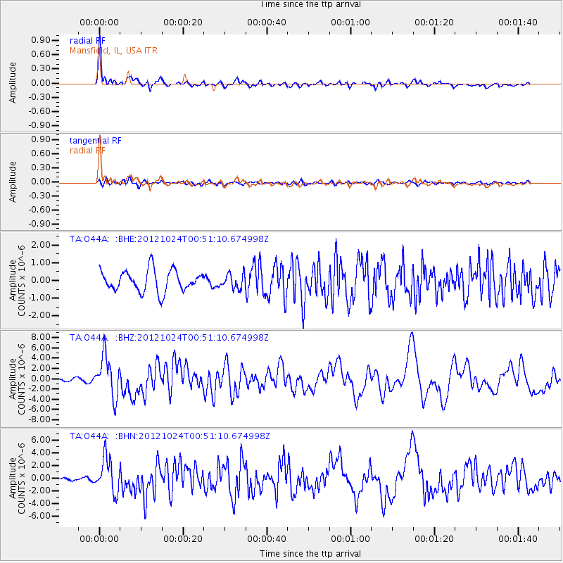
Signal To Noise
| Channel | StoN | STA | LTA |
| TA:O44A: :BHZ:20121024T00:51:10.674998Z | 7.858906 | 4.042156E-6 | 5.143408E-7 |
| TA:O44A: :BHN:20121024T00:51:10.674998Z | 7.1365476 | 2.7546032E-6 | 3.8598537E-7 |
| TA:O44A: :BHE:20121024T00:51:10.674998Z | 0.6900514 | 4.1116465E-7 | 5.958464E-7 |
| Arrivals |
| Ps | 3.6 SECOND |
| PpPs | 8.8 SECOND |
| PsPs/PpSs | 12 SECOND |


