You are here: Home > Network List > TA - USArray Transportable Network (new EarthScope stations) Stations List
> Station N44A Piper City, IL, USA > Earthquake Result Viewer
N44A Piper City, IL, USA - Earthquake Result Viewer
| Earthquake location: |
Costa Rica |
| Earthquake latitude/longitude: |
10.1/-85.3 |
| Earthquake time(UTC): |
2012/10/24 (298) 00:45:32 GMT |
| Earthquake Depth: |
17 km |
| Earthquake Magnitude: |
6.0 MB, 6.2 MS, 6.5 MW, 6.4 MW |
| Earthquake Catalog/Contributor: |
WHDF/NEIC |
|
| Network: |
TA USArray Transportable Network (new EarthScope stations) |
| Station: |
N44A Piper City, IL, USA |
| Lat/Lon: |
40.80 N/88.13 W |
| Elevation: |
202 m |
|
| Distance: |
30.7 deg |
| Az: |
355.78 deg |
| Baz: |
174.523 deg |
| Ray Param: |
0.079257764 |
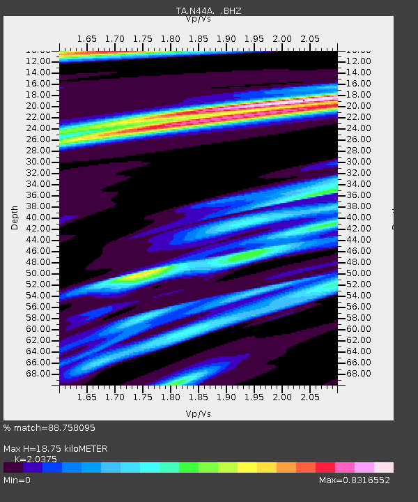
| Estimated Moho Depth: |
18.75 km |
| Estimated Crust Vp/Vs: |
2.04 |
| Assumed Crust Vp: |
6.498 km/s |
| Estimated Crust Vs: |
3.189 km/s |
| Estimated Crust Poisson's Ratio: |
0.34 |
|
| Radial Match: |
88.758095 % |
| Radial Bump: |
361 |
| Transverse Match: |
61.7997 % |
| Transverse Bump: |
400 |
| SOD ConfigId: |
478790 |
| Insert Time: |
2013-02-25 15:42:16.514 +0000 |
| GWidth: |
2.5 |
| Max Bumps: |
400 |
| Tol: |
0.001 |
|

Signal To Noise
| Channel | StoN | STA | LTA |
| TA:N44A: :BHZ:20121024T00:51:16.074991Z | 4.3519216 | 3.333701E-6 | 7.6602964E-7 |
| TA:N44A: :BHN:20121024T00:51:16.074991Z | 3.4238691 | 1.6529951E-6 | 4.827857E-7 |
| TA:N44A: :BHE:20121024T00:51:16.074991Z | 0.6500063 | 4.3179733E-7 | 6.6429715E-7 |
| Arrivals |
| Ps | 3.2 SECOND |
| PpPs | 8.2 SECOND |
| PsPs/PpSs | 11 SECOND |


