You are here: Home > Network List > TA - USArray Transportable Network (new EarthScope stations) Stations List
> Station O45A Potomac, IL, USA > Earthquake Result Viewer
O45A Potomac, IL, USA - Earthquake Result Viewer
| Earthquake location: |
Costa Rica |
| Earthquake latitude/longitude: |
10.1/-85.3 |
| Earthquake time(UTC): |
2012/10/24 (298) 00:45:32 GMT |
| Earthquake Depth: |
17 km |
| Earthquake Magnitude: |
6.0 MB, 6.2 MS, 6.5 MW, 6.4 MW |
| Earthquake Catalog/Contributor: |
WHDF/NEIC |
|
| Network: |
TA USArray Transportable Network (new EarthScope stations) |
| Station: |
O45A Potomac, IL, USA |
| Lat/Lon: |
40.25 N/87.72 W |
| Elevation: |
208 m |
|
| Distance: |
30.1 deg |
| Az: |
356.297 deg |
| Baz: |
175.234 deg |
| Ray Param: |
0.07940788 |
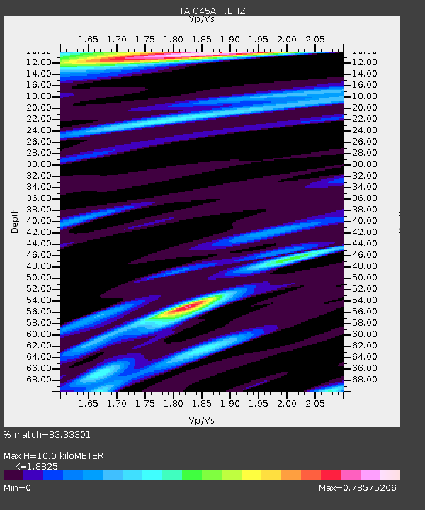
| Estimated Moho Depth: |
10.0 km |
| Estimated Crust Vp/Vs: |
1.88 |
| Assumed Crust Vp: |
6.498 km/s |
| Estimated Crust Vs: |
3.452 km/s |
| Estimated Crust Poisson's Ratio: |
0.30 |
|
| Radial Match: |
83.33301 % |
| Radial Bump: |
320 |
| Transverse Match: |
57.9356 % |
| Transverse Bump: |
400 |
| SOD ConfigId: |
478790 |
| Insert Time: |
2013-02-25 15:42:26.801 +0000 |
| GWidth: |
2.5 |
| Max Bumps: |
400 |
| Tol: |
0.001 |
|
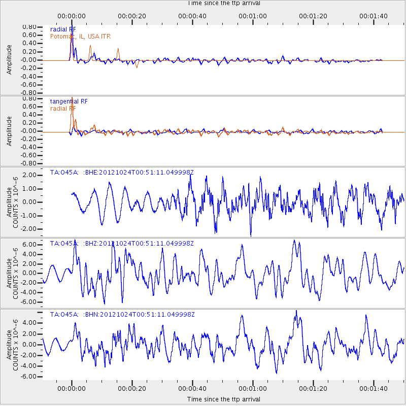
Signal To Noise
| Channel | StoN | STA | LTA |
| TA:O45A: :BHZ:20121024T00:51:11.049998Z | 3.58456 | 3.211324E-6 | 8.958768E-7 |
| TA:O45A: :BHN:20121024T00:51:11.049998Z | 2.2786655 | 1.9753295E-6 | 8.6687993E-7 |
| TA:O45A: :BHE:20121024T00:51:11.049998Z | 0.46482205 | 3.4264403E-7 | 7.3715097E-7 |
| Arrivals |
| Ps | 1.5 SECOND |
| PpPs | 4.1 SECOND |
| PsPs/PpSs | 5.6 SECOND |


