You are here: Home > Network List > TA - USArray Transportable Network (new EarthScope stations) Stations List
> Station N50A Nevada, OH, USA > Earthquake Result Viewer
N50A Nevada, OH, USA - Earthquake Result Viewer
| Earthquake location: |
Costa Rica |
| Earthquake latitude/longitude: |
10.1/-85.3 |
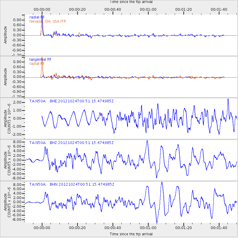
| Earthquake time(UTC): |
2012/10/24 (298) 00:45:32 GMT |
| Earthquake Depth: |
17 km |
| Earthquake Magnitude: |
6.0 MB, 6.2 MS, 6.5 MW, 6.4 MW |
| Earthquake Catalog/Contributor: |
WHDF/NEIC |
|
| Network: |
TA USArray Transportable Network (new EarthScope stations) |
| Station: |
N50A Nevada, OH, USA |
| Lat/Lon: |
40.77 N/83.15 W |
| Elevation: |
277 m |
|
| Distance: |
30.6 deg |
| Az: |
3.206 deg |
| Baz: |
184.158 deg |
| Ray Param: |
0.079275586 |
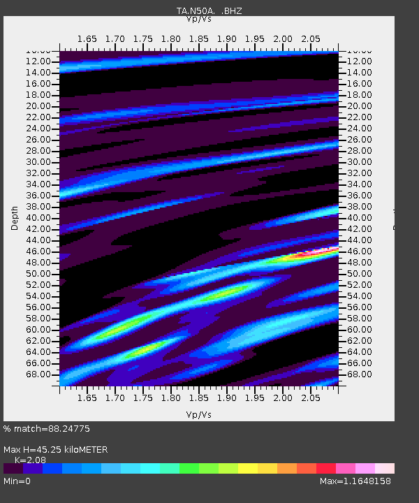
| Estimated Moho Depth: |
45.25 km |
| Estimated Crust Vp/Vs: |
2.08 |
| Assumed Crust Vp: |
6.498 km/s |
| Estimated Crust Vs: |
3.124 km/s |
| Estimated Crust Poisson's Ratio: |
0.35 |
|
| Radial Match: |
88.24775 % |
| Radial Bump: |
323 |
| Transverse Match: |
47.51562 % |
| Transverse Bump: |
400 |
| SOD ConfigId: |
478790 |
| Insert Time: |
2013-02-25 15:43:10.283 +0000 |
| GWidth: |
2.5 |
| Max Bumps: |
400 |
| Tol: |
0.001 |
|
Signal To Noise
| Channel | StoN | STA | LTA |
| TA:N50A: :BHZ:20121024T00:51:15.474985Z | 4.0537486 | 2.9126586E-6 | 7.185099E-7 |
| TA:N50A: :BHN:20121024T00:51:15.474985Z | 5.7730665 | 2.4645044E-6 | 4.2689695E-7 |
| TA:N50A: :BHE:20121024T00:51:15.474985Z | 0.7409385 | 4.5511962E-7 | 6.142475E-7 |
| Arrivals |
| Ps | 8.1 SECOND |
| PpPs | 20 SECOND |
| PsPs/PpSs | 28 SECOND |


