You are here: Home > Network List > TA - USArray Transportable Network (new EarthScope stations) Stations List
> Station O48A Farmland, IN, USA > Earthquake Result Viewer
O48A Farmland, IN, USA - Earthquake Result Viewer

| Earthquake location: |
Costa Rica |
| Earthquake latitude/longitude: |
10.1/-85.3 |
| Earthquake time(UTC): |
2012/10/24 (298) 00:45:32 GMT |
| Earthquake Depth: |
17 km |
| Earthquake Magnitude: |
6.0 MB, 6.2 MS, 6.5 MW, 6.4 MW |
| Earthquake Catalog/Contributor: |
WHDF/NEIC |
|
| Network: |
TA USArray Transportable Network (new EarthScope stations) |
| Station: |
O48A Farmland, IN, USA |
| Lat/Lon: |
40.26 N/85.16 W |
| Elevation: |
300 m |
|
| Distance: |
30.0 deg |
| Az: |
0.218 deg |
| Baz: |
180.281 deg |
| Ray Param: |
0.079425946 |
| Estimated Moho Depth: |
34.25 km |
| Estimated Crust Vp/Vs: |
2.10 |
| Assumed Crust Vp: |
6.498 km/s |
| Estimated Crust Vs: |
3.098 km/s |
| Estimated Crust Poisson's Ratio: |
0.35 |
|
| Radial Match: |
84.164925 % |
| Radial Bump: |
302 |
| Transverse Match: |
63.34691 % |
| Transverse Bump: |
400 |
| SOD ConfigId: |
478790 |
| Insert Time: |
2013-02-25 15:43:20.753 +0000 |
| GWidth: |
2.5 |
| Max Bumps: |
400 |
| Tol: |
0.001 |
|
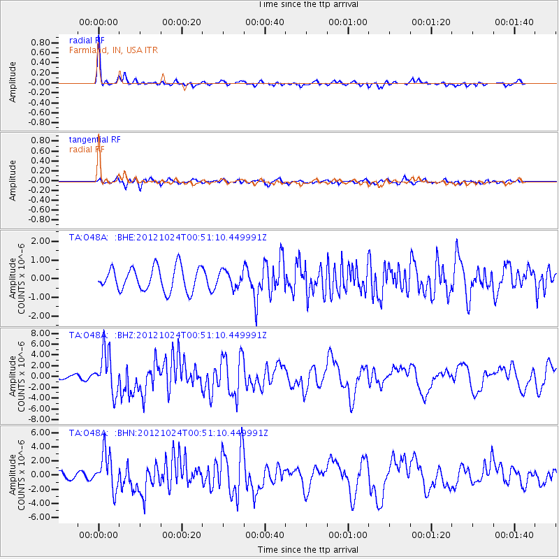
Signal To Noise
| Channel | StoN | STA | LTA |
| TA:O48A: :BHZ:20121024T00:51:10.449991Z | 7.4581165 | 3.930774E-6 | 5.2704644E-7 |
| TA:O48A: :BHN:20121024T00:51:10.449991Z | 6.6921163 | 2.6484377E-6 | 3.9575488E-7 |
| TA:O48A: :BHE:20121024T00:51:10.449991Z | 0.68645096 | 4.3299735E-7 | 6.307768E-7 |
| Arrivals |
| Ps | 6.2 SECOND |
| PpPs | 15 SECOND |
| PsPs/PpSs | 21 SECOND |


