You are here: Home > Network List > TA - USArray Transportable Network (new EarthScope stations) Stations List
> Station M49A Liberty Center, OH, USA > Earthquake Result Viewer
M49A Liberty Center, OH, USA - Earthquake Result Viewer
| Earthquake location: |
Costa Rica |
| Earthquake latitude/longitude: |
10.1/-85.3 |
| Earthquake time(UTC): |
2012/10/24 (298) 00:45:32 GMT |
| Earthquake Depth: |
17 km |
| Earthquake Magnitude: |
6.0 MB, 6.2 MS, 6.5 MW, 6.4 MW |
| Earthquake Catalog/Contributor: |
WHDF/NEIC |
|
| Network: |
TA USArray Transportable Network (new EarthScope stations) |
| Station: |
M49A Liberty Center, OH, USA |
| Lat/Lon: |
41.47 N/83.98 W |
| Elevation: |
203 m |
|
| Distance: |
31.3 deg |
| Az: |
1.914 deg |
| Baz: |
182.509 deg |
| Ray Param: |
0.07910083 |
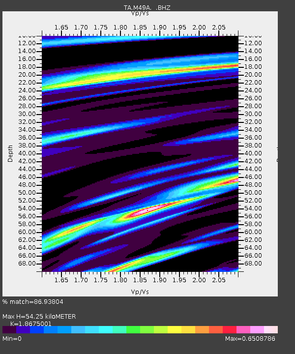
| Estimated Moho Depth: |
54.25 km |
| Estimated Crust Vp/Vs: |
1.87 |
| Assumed Crust Vp: |
6.498 km/s |
| Estimated Crust Vs: |
3.479 km/s |
| Estimated Crust Poisson's Ratio: |
0.30 |
|
| Radial Match: |
86.93804 % |
| Radial Bump: |
263 |
| Transverse Match: |
69.148415 % |
| Transverse Bump: |
400 |
| SOD ConfigId: |
478790 |
| Insert Time: |
2013-02-25 15:43:23.957 +0000 |
| GWidth: |
2.5 |
| Max Bumps: |
400 |
| Tol: |
0.001 |
|
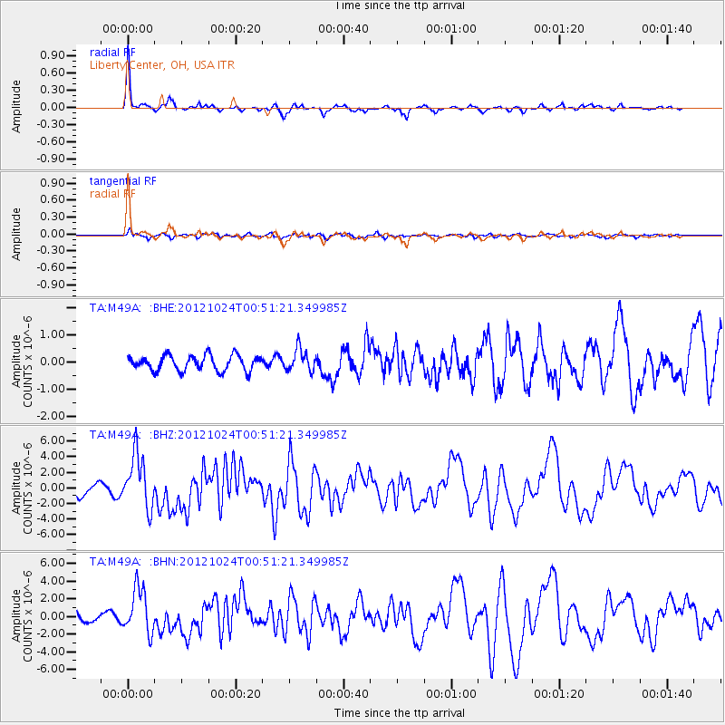
Signal To Noise
| Channel | StoN | STA | LTA |
| TA:M49A: :BHZ:20121024T00:51:21.349985Z | 4.3806386 | 3.4446384E-6 | 7.863325E-7 |
| TA:M49A: :BHN:20121024T00:51:21.349985Z | 4.1086454 | 2.56093E-6 | 6.233028E-7 |
| TA:M49A: :BHE:20121024T00:51:21.349985Z | 1.44341 | 4.0529397E-7 | 2.8078924E-7 |
| Arrivals |
| Ps | 7.8 SECOND |
| PpPs | 22 SECOND |
| PsPs/PpSs | 30 SECOND |


