You are here: Home > Network List > TA - USArray Transportable Network (new EarthScope stations) Stations List
> Station N49A Columbus Grove, OH, USA > Earthquake Result Viewer
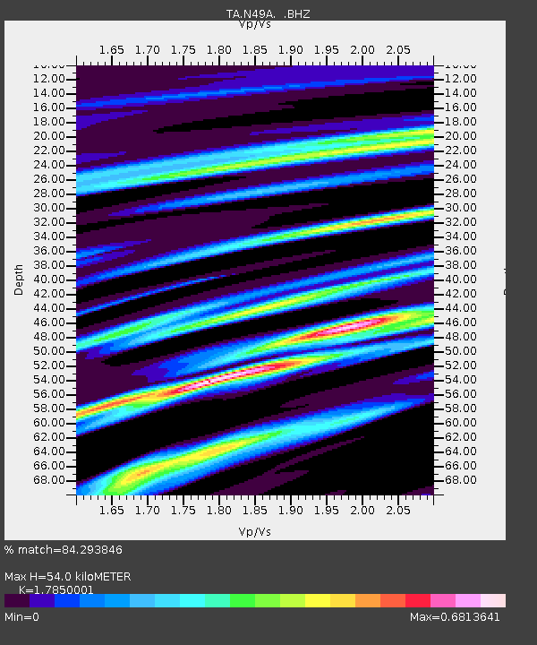
N49A Columbus Grove, OH, USA - Earthquake Result Viewer
| Earthquake location: |
Costa Rica |
| Earthquake latitude/longitude: |
10.1/-85.3 |
| Earthquake time(UTC): |
2012/10/24 (298) 00:45:32 GMT |
| Earthquake Depth: |
17 km |
| Earthquake Magnitude: |
6.0 MB, 6.2 MS, 6.5 MW, 6.4 MW |
| Earthquake Catalog/Contributor: |
WHDF/NEIC |
|
| Network: |
TA USArray Transportable Network (new EarthScope stations) |
| Station: |
N49A Columbus Grove, OH, USA |
| Lat/Lon: |
40.92 N/84.18 W |
| Elevation: |
225 m |
|
| Distance: |
30.7 deg |
| Az: |
1.654 deg |
| Baz: |
182.15 deg |
| Ray Param: |
0.07924738 |
| Estimated Moho Depth: |
54.0 km |
| Estimated Crust Vp/Vs: |
1.79 |
| Assumed Crust Vp: |
6.498 km/s |
| Estimated Crust Vs: |
3.64 km/s |
| Estimated Crust Poisson's Ratio: |
0.27 |
|
| Radial Match: |
84.293846 % |
| Radial Bump: |
342 |
| Transverse Match: |
66.00658 % |
| Transverse Bump: |
400 |
| SOD ConfigId: |
478790 |
| Insert Time: |
2013-02-25 15:44:29.297 +0000 |
| GWidth: |
2.5 |
| Max Bumps: |
400 |
| Tol: |
0.001 |
|

Signal To Noise
| Channel | StoN | STA | LTA |
| TA:N49A: :BHZ:20121024T00:51:16.424998Z | 7.42106 | 3.9020997E-6 | 5.258143E-7 |
| TA:N49A: :BHN:20121024T00:51:16.424998Z | 5.7660136 | 2.7943793E-6 | 4.846293E-7 |
| TA:N49A: :BHE:20121024T00:51:16.424998Z | 1.577376 | 4.4617013E-7 | 2.8285592E-7 |
| Arrivals |
| Ps | 7.1 SECOND |
| PpPs | 21 SECOND |
| PsPs/PpSs | 28 SECOND |


