You are here: Home > Network List > TA - USArray Transportable Network (new EarthScope stations) Stations List
> Station M47A Cromwell, IN, USA > Earthquake Result Viewer
M47A Cromwell, IN, USA - Earthquake Result Viewer
| Earthquake location: |
Costa Rica |
| Earthquake latitude/longitude: |
10.1/-85.3 |
| Earthquake time(UTC): |
2012/10/24 (298) 00:45:32 GMT |
| Earthquake Depth: |
17 km |
| Earthquake Magnitude: |
6.0 MB, 6.2 MS, 6.5 MW, 6.4 MW |
| Earthquake Catalog/Contributor: |
WHDF/NEIC |
|
| Network: |
TA USArray Transportable Network (new EarthScope stations) |
| Station: |
M47A Cromwell, IN, USA |
| Lat/Lon: |
41.36 N/85.62 W |
| Elevation: |
283 m |
|
| Distance: |
31.2 deg |
| Az: |
359.529 deg |
| Baz: |
179.384 deg |
| Ray Param: |
0.07913641 |
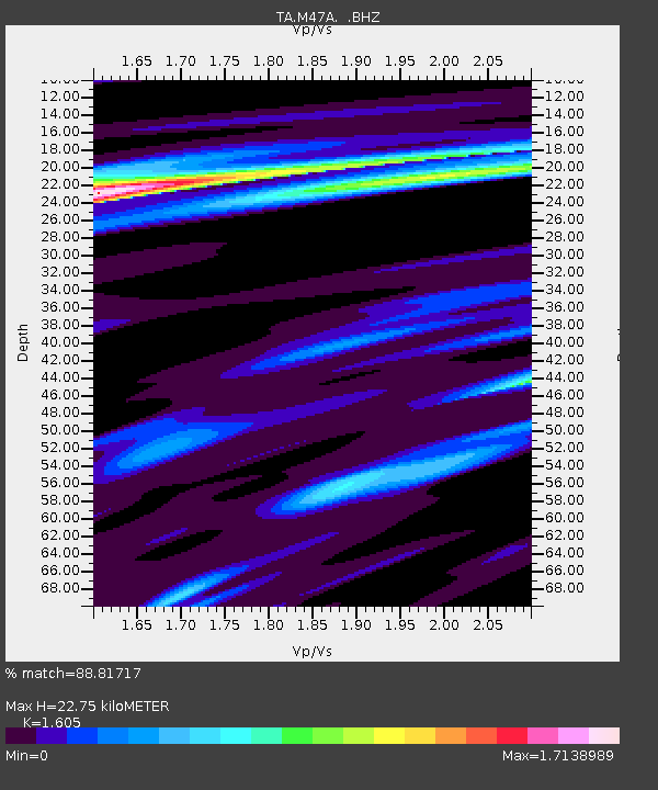
| Estimated Moho Depth: |
22.75 km |
| Estimated Crust Vp/Vs: |
1.61 |
| Assumed Crust Vp: |
6.498 km/s |
| Estimated Crust Vs: |
4.048 km/s |
| Estimated Crust Poisson's Ratio: |
0.18 |
|
| Radial Match: |
88.81717 % |
| Radial Bump: |
277 |
| Transverse Match: |
59.07821 % |
| Transverse Bump: |
388 |
| SOD ConfigId: |
478790 |
| Insert Time: |
2013-02-25 15:44:29.583 +0000 |
| GWidth: |
2.5 |
| Max Bumps: |
400 |
| Tol: |
0.001 |
|
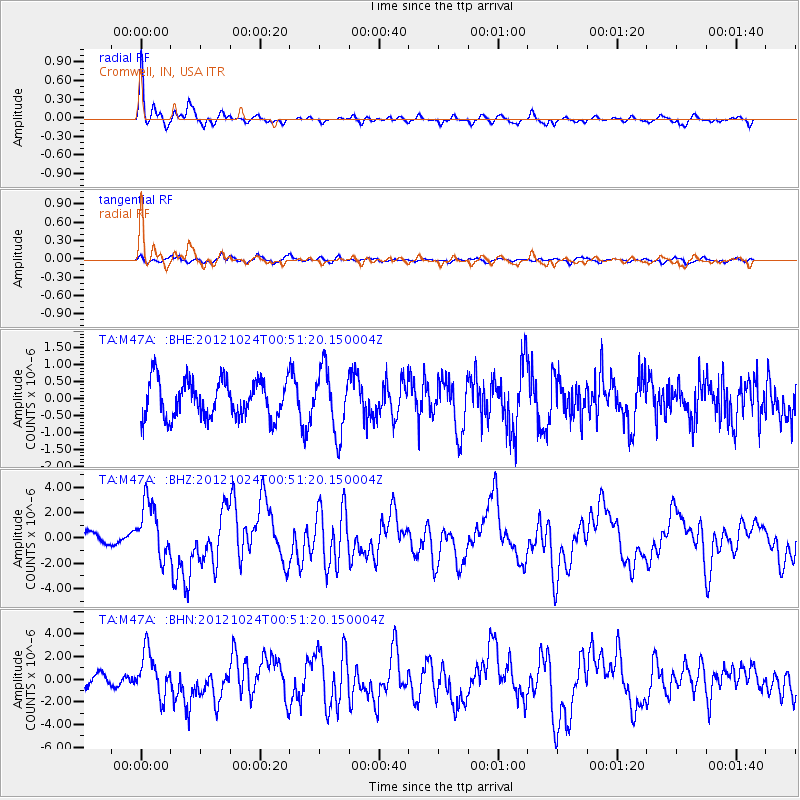
Signal To Noise
| Channel | StoN | STA | LTA |
| TA:M47A: :BHZ:20121024T00:51:20.150004Z | 3.4046693 | 2.2076078E-6 | 6.48406E-7 |
| TA:M47A: :BHN:20121024T00:51:20.150004Z | 3.3330421 | 1.960637E-6 | 5.8824253E-7 |
| TA:M47A: :BHE:20121024T00:51:20.150004Z | 1.6650406 | 9.18148E-7 | 5.5142675E-7 |
| Arrivals |
| Ps | 2.3 SECOND |
| PpPs | 8.3 SECOND |
| PsPs/PpSs | 11 SECOND |


