You are here: Home > Network List > TA - USArray Transportable Network (new EarthScope stations) Stations List
> Station K47A Vremontville, MI, USA > Earthquake Result Viewer
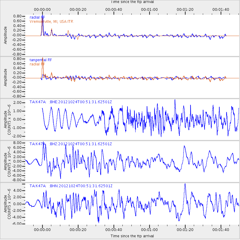
K47A Vremontville, MI, USA - Earthquake Result Viewer
*The percent match for this event was below the threshold and hence no stack was calculated.
| Earthquake location: |
Costa Rica |
| Earthquake latitude/longitude: |
10.1/-85.3 |
| Earthquake time(UTC): |
2012/10/24 (298) 00:45:32 GMT |
| Earthquake Depth: |
17 km |
| Earthquake Magnitude: |
6.0 MB, 6.2 MS, 6.5 MW, 6.4 MW |
| Earthquake Catalog/Contributor: |
WHDF/NEIC |
|
| Network: |
TA USArray Transportable Network (new EarthScope stations) |
| Station: |
K47A Vremontville, MI, USA |
| Lat/Lon: |
42.67 N/85.00 W |
| Elevation: |
275 m |
|
| Distance: |
32.5 deg |
| Az: |
0.41 deg |
| Baz: |
180.548 deg |
| Ray Param: |
$rayparam |
*The percent match for this event was below the threshold and hence was not used in the summary stack. |
|
| Radial Match: |
76.95965 % |
| Radial Bump: |
363 |
| Transverse Match: |
56.5035 % |
| Transverse Bump: |
400 |
| SOD ConfigId: |
478790 |
| Insert Time: |
2013-02-25 15:44:51.470 +0000 |
| GWidth: |
2.5 |
| Max Bumps: |
400 |
| Tol: |
0.001 |
|
Signal To Noise
| Channel | StoN | STA | LTA |
| TA:K47A: :BHZ:20121024T00:51:31.62501Z | 5.4971766 | 3.962494E-6 | 7.208235E-7 |
| TA:K47A: :BHN:20121024T00:51:31.62501Z | 5.0894732 | 1.6601576E-6 | 3.261944E-7 |
| TA:K47A: :BHE:20121024T00:51:31.62501Z | 0.73399013 | 5.5978666E-7 | 7.6266235E-7 |
| Arrivals |
| Ps | |
| PpPs | |
| PsPs/PpSs | |


