You are here: Home > Network List > UW - Pacific Northwest Regional Seismic Network Stations List
> Station MRBL Marblemount, WA, USA > Earthquake Result Viewer
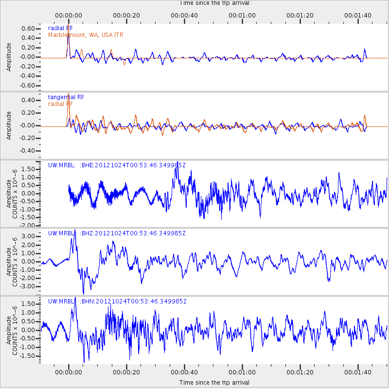
MRBL Marblemount, WA, USA - Earthquake Result Viewer
*The percent match for this event was below the threshold and hence no stack was calculated.
| Earthquake location: |
Costa Rica |
| Earthquake latitude/longitude: |
10.1/-85.3 |
| Earthquake time(UTC): |
2012/10/24 (298) 00:45:32 GMT |
| Earthquake Depth: |
17 km |
| Earthquake Magnitude: |
6.0 MB, 6.2 MS, 6.5 MW, 6.4 MW |
| Earthquake Catalog/Contributor: |
WHDF/NEIC |
|
| Network: |
UW Pacific Northwest Regional Seismic Network |
| Station: |
MRBL Marblemount, WA, USA |
| Lat/Lon: |
48.52 N/121.48 W |
| Elevation: |
75 m |
|
| Distance: |
48.8 deg |
| Az: |
328.564 deg |
| Baz: |
129.424 deg |
| Ray Param: |
$rayparam |
*The percent match for this event was below the threshold and hence was not used in the summary stack. |
|
| Radial Match: |
61.150555 % |
| Radial Bump: |
400 |
| Transverse Match: |
60.612495 % |
| Transverse Bump: |
400 |
| SOD ConfigId: |
478790 |
| Insert Time: |
2013-02-25 15:47:18.318 +0000 |
| GWidth: |
2.5 |
| Max Bumps: |
400 |
| Tol: |
0.001 |
|
Signal To Noise
| Channel | StoN | STA | LTA |
| UW:MRBL: :BHZ:20121024T00:53:46.349985Z | 7.920165 | 1.7627308E-6 | 2.2256238E-7 |
| UW:MRBL: :BHN:20121024T00:53:46.349985Z | 2.6329103 | 7.940677E-7 | 3.0159316E-7 |
| UW:MRBL: :BHE:20121024T00:53:46.349985Z | 1.2560866 | 4.5803418E-7 | 3.6465175E-7 |
| Arrivals |
| Ps | |
| PpPs | |
| PsPs/PpSs | |


