You are here: Home > Network List > TA - USArray Transportable Network (new EarthScope stations) Stations List
> Station L41A Preston, IA, USA > Earthquake Result Viewer
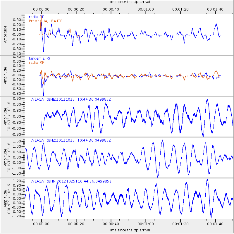
L41A Preston, IA, USA - Earthquake Result Viewer
*The percent match for this event was below the threshold and hence no stack was calculated.
| Earthquake location: |
Near East Coast Of Honshu, Japan |
| Earthquake latitude/longitude: |
38.3/141.7 |
| Earthquake time(UTC): |
2012/10/25 (299) 10:32:28 GMT |
| Earthquake Depth: |
56 km |
| Earthquake Magnitude: |
5.5 MB, 5.6 MW, 5.7 MW |
| Earthquake Catalog/Contributor: |
WHDF/NEIC |
|
| Network: |
TA USArray Transportable Network (new EarthScope stations) |
| Station: |
L41A Preston, IA, USA |
| Lat/Lon: |
42.08 N/90.50 W |
| Elevation: |
238 m |
|
| Distance: |
87.0 deg |
| Az: |
36.091 deg |
| Baz: |
321.502 deg |
| Ray Param: |
$rayparam |
*The percent match for this event was below the threshold and hence was not used in the summary stack. |
|
| Radial Match: |
63.54258 % |
| Radial Bump: |
400 |
| Transverse Match: |
87.2925 % |
| Transverse Bump: |
400 |
| SOD ConfigId: |
478790 |
| Insert Time: |
2013-02-25 16:01:38.905 +0000 |
| GWidth: |
2.5 |
| Max Bumps: |
400 |
| Tol: |
0.001 |
|
Signal To Noise
| Channel | StoN | STA | LTA |
| TA:L41A: :BHZ:20121025T10:44:36.049985Z | 2.2239084 | 7.949376E-7 | 3.574507E-7 |
| TA:L41A: :BHN:20121025T10:44:36.049985Z | 1.5315119 | 6.113187E-7 | 3.9916026E-7 |
| TA:L41A: :BHE:20121025T10:44:36.049985Z | 2.071423 | 5.105603E-7 | 2.4647804E-7 |
| Arrivals |
| Ps | |
| PpPs | |
| PsPs/PpSs | |


