You are here: Home > Network List > TA - USArray Transportable Network (new EarthScope stations) Stations List
> Station V48A Smith Brothers Farm, Spring Hill, TN, USA > Earthquake Result Viewer
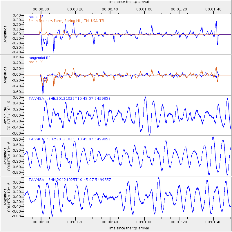
V48A Smith Brothers Farm, Spring Hill, TN, USA - Earthquake Result Viewer
*The percent match for this event was below the threshold and hence no stack was calculated.
| Earthquake location: |
Near East Coast Of Honshu, Japan |
| Earthquake latitude/longitude: |
38.3/141.7 |
| Earthquake time(UTC): |
2012/10/25 (299) 10:32:28 GMT |
| Earthquake Depth: |
56 km |
| Earthquake Magnitude: |
5.5 MB, 5.6 MW, 5.7 MW |
| Earthquake Catalog/Contributor: |
WHDF/NEIC |
|
| Network: |
TA USArray Transportable Network (new EarthScope stations) |
| Station: |
V48A Smith Brothers Farm, Spring Hill, TN, USA |
| Lat/Lon: |
35.74 N/86.82 W |
| Elevation: |
278 m |
|
| Distance: |
93.7 deg |
| Az: |
37.646 deg |
| Baz: |
323.796 deg |
| Ray Param: |
$rayparam |
*The percent match for this event was below the threshold and hence was not used in the summary stack. |
|
| Radial Match: |
76.425064 % |
| Radial Bump: |
400 |
| Transverse Match: |
71.60723 % |
| Transverse Bump: |
369 |
| SOD ConfigId: |
478790 |
| Insert Time: |
2013-02-25 16:02:27.731 +0000 |
| GWidth: |
2.5 |
| Max Bumps: |
400 |
| Tol: |
0.001 |
|
Signal To Noise
| Channel | StoN | STA | LTA |
| TA:V48A: :BHZ:20121025T10:45:07.549985Z | 2.4751387 | 5.732389E-7 | 2.3159869E-7 |
| TA:V48A: :BHN:20121025T10:45:07.549985Z | 2.4016244 | 4.6362604E-7 | 1.9304686E-7 |
| TA:V48A: :BHE:20121025T10:45:07.549985Z | 0.7983118 | 1.8099666E-7 | 2.2672427E-7 |
| Arrivals |
| Ps | |
| PpPs | |
| PsPs/PpSs | |


