You are here: Home > Network List > G - GEOSCOPE Stations List
> Station WUS Wushi, Xinjiang Uygur, China > Earthquake Result Viewer
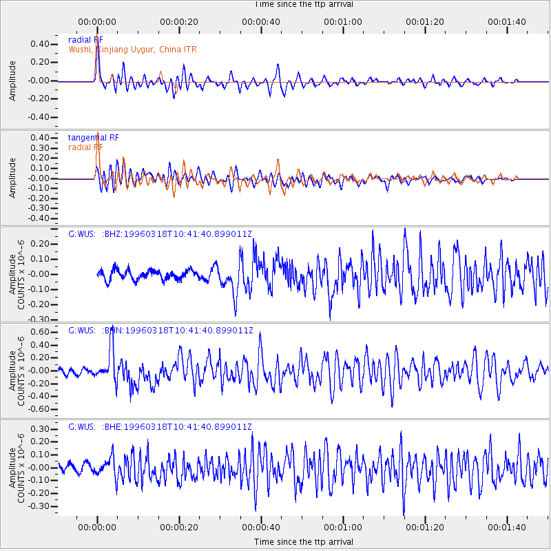
WUS Wushi, Xinjiang Uygur, China - Earthquake Result Viewer
*The percent match for this event was below the threshold and hence no stack was calculated.
| Earthquake location: |
Eastern New Guinea Reg., P.N.G. |
| Earthquake latitude/longitude: |
-6.2/147.8 |
| Earthquake time(UTC): |
1996/03/18 (078) 10:30:15 GMT |
| Earthquake Depth: |
33 km |
| Earthquake Magnitude: |
5.5 MB, 5.6 MS, 5.8 UNKNOWN, 6.0 ML |
| Earthquake Catalog/Contributor: |
WHDF/NEIC |
|
| Network: |
G GEOSCOPE |
| Station: |
WUS Wushi, Xinjiang Uygur, China |
| Lat/Lon: |
41.20 N/79.22 E |
| Elevation: |
1457 m |
|
| Distance: |
78.2 deg |
| Az: |
314.143 deg |
| Baz: |
109.0 deg |
| Ray Param: |
$rayparam |
*The percent match for this event was below the threshold and hence was not used in the summary stack. |
|
| Radial Match: |
79.27981 % |
| Radial Bump: |
400 |
| Transverse Match: |
65.67009 % |
| Transverse Bump: |
400 |
| SOD ConfigId: |
4480 |
| Insert Time: |
2010-02-27 01:06:49.234 +0000 |
| GWidth: |
2.5 |
| Max Bumps: |
400 |
| Tol: |
0.001 |
|
Signal To Noise
| Channel | StoN | STA | LTA |
| G:WUS: :BHN:19960318T10:41:40.899011Z | 7.296068 | 2.7374725E-7 | 3.7519833E-8 |
| G:WUS: :BHE:19960318T10:41:40.899011Z | 1.8939427 | 7.924637E-8 | 4.184201E-8 |
| G:WUS: :BHZ:19960318T10:41:40.899011Z | 3.3360777 | 1.02445206E-7 | 3.070828E-8 |
| Arrivals |
| Ps | |
| PpPs | |
| PsPs/PpSs | |


