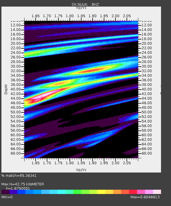
NUUK Nuuk, Greenland - Earthquake Result Viewer

Earthquake location: Queen Charlotte Islands Region
Earthquake latitude/longitude: 52.8/-132.1
Earthquake time(UTC): 2012/10/28 (302) 03:04:08 GMT
Earthquake Depth: 14 km
Earthquake Magnitude: 6.5 MB, 7.5 MS, 7.8 MW, 7.8 MW
Earthquake Catalog/Contributor: WHDF/NEIC
Network: DK Danish Seismological Network
Station: NUUK Nuuk, Greenland
Lat/Lon: 64.18 N/51.67 W
Elevation: 110 m
Distance: 40.7 deg
Az: 41.489 deg
Baz: 293.234 deg
Ray Param: 0.07425313
Estimated Moho Depth: 42.75 km
Estimated Crust Vp/Vs: 1.68
Assumed Crust Vp: 6.459 km/s
Estimated Crust Vs: 3.856 km/s
Estimated Crust Poisson's Ratio: 0.22
Radial Match: 95.36341 %
Radial Bump: 259
Transverse Match: 88.51669 %
Transverse Bump: 400
SOD ConfigId: 478790
Insert Time: 2013-03-01 08:19:43.383 +0000
GWidth: 2.5
Max Bumps: 400
Tol: 0.001

Signal To Noise

ChannelStoNSTALTA
DK:NUUK: :BHZ:20121028T03:11:17.749993Z8.1405533.515919E-64.3190173E-7
DK:NUUK: :BHN:20121028T03:11:17.749993Z5.54737661.2687123E-62.287049E-7
DK:NUUK: :BHE:20121028T03:11:17.749993Z5.50005632.888589E-65.2519266E-7
Arrivals
Ps4.8 SECOND
PpPs16 SECOND
PsPs/PpSs21 SECOND