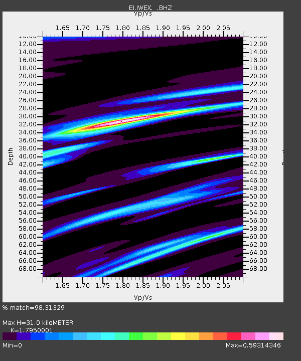
IWEX CARRICKBYRNE, CO WEXFORD - Earthquake Result Viewer

Earthquake location: Queen Charlotte Islands Region
Earthquake latitude/longitude: 52.8/-132.1
Earthquake time(UTC): 2012/10/28 (302) 03:04:08 GMT
Earthquake Depth: 14 km
Earthquake Magnitude: 6.5 MB, 7.5 MS, 7.8 MW, 7.8 MW
Earthquake Catalog/Contributor: WHDF/NEIC
Network: EI Irish National Seismic Network (INSN)
Station: IWEX CARRICKBYRNE, CO WEXFORD
Lat/Lon: 52.37 N/6.77 W
Elevation: 180 m
Distance: 65.6 deg
Az: 33.301 deg
Baz: 327.051 deg
Ray Param: 0.058124892
Estimated Moho Depth: 31.0 km
Estimated Crust Vp/Vs: 1.80
Assumed Crust Vp: 6.276 km/s
Estimated Crust Vs: 3.496 km/s
Estimated Crust Poisson's Ratio: 0.27
Radial Match: 98.31329 %
Radial Bump: 252
Transverse Match: 90.39204 %
Transverse Bump: 400
SOD ConfigId: 478790
Insert Time: 2013-03-01 08:19:58.791 +0000
GWidth: 2.5
Max Bumps: 400
Tol: 0.001

Signal To Noise

ChannelStoNSTALTA
EI:IWEX: :BHZ:20121028T03:14:21.294976Z4.10940032.721372E-66.6223095E-7
EI:IWEX: :BHN:20121028T03:14:21.294976Z1.82635331.1031362E-66.0401027E-7
EI:IWEX: :BHE:20121028T03:14:21.294976Z2.12842561.0403313E-64.8877973E-7
Arrivals
Ps4.1 SECOND
PpPs13 SECOND
PsPs/PpSs17 SECOND