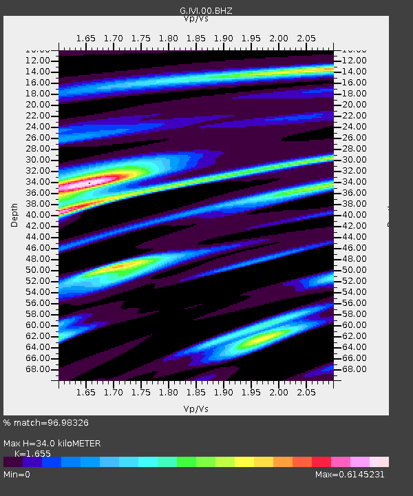
IVI Ivittuut, Greenland - Earthquake Result Viewer
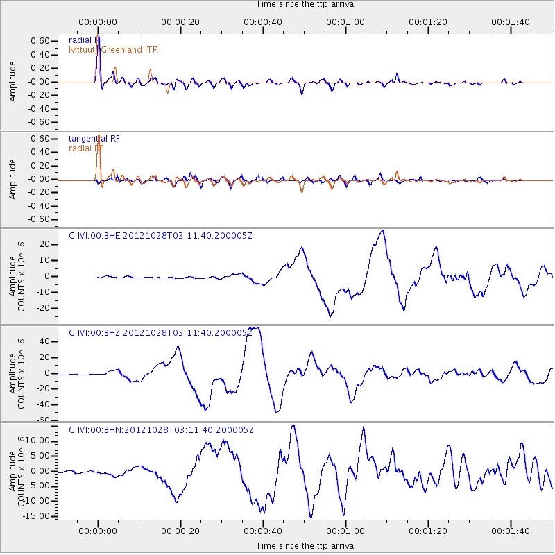
Earthquake location: Queen Charlotte Islands Region
Earthquake latitude/longitude: 52.8/-132.1
Earthquake time(UTC): 2012/10/28 (302) 03:04:08 GMT
Earthquake Depth: 14 km
Earthquake Magnitude: 6.5 MB, 7.5 MS, 7.8 MW, 7.8 MW
Earthquake Catalog/Contributor: WHDF/NEIC
Network: G GEOSCOPE
Station: IVI Ivittuut, Greenland
Lat/Lon: 61.21 N/48.17 W
Elevation: 15 m
Distance: 43.4 deg
Az: 44.452 deg
Baz: 298.538 deg
Ray Param: 0.072547026
Estimated Moho Depth: 34.0 km
Estimated Crust Vp/Vs: 1.65
Assumed Crust Vp: 6.472 km/s
Estimated Crust Vs: 3.91 km/s
Estimated Crust Poisson's Ratio: 0.21
Radial Match: 96.98326 %
Radial Bump: 400
Transverse Match: 91.41088 %
Transverse Bump: 400
SOD ConfigId: 478790
Insert Time: 2013-03-01 08:20:31.144 +0000
GWidth: 2.5
Max Bumps: 400
Tol: 0.001

Signal To Noise

ChannelStoNSTALTA
G:IVI:00:BHZ:20121028T03:11:40.200005Z5.9293663.2766377E-65.5261177E-7
G:IVI:00:BHN:20121028T03:11:40.200005Z2.2236037.755703E-73.487899E-7
G:IVI:00:BHE:20121028T03:11:40.200005Z3.9042041.5629479E-64.0032438E-7
Arrivals
Ps3.7 SECOND
PpPs13 SECOND
PsPs/PpSs17 SECOND