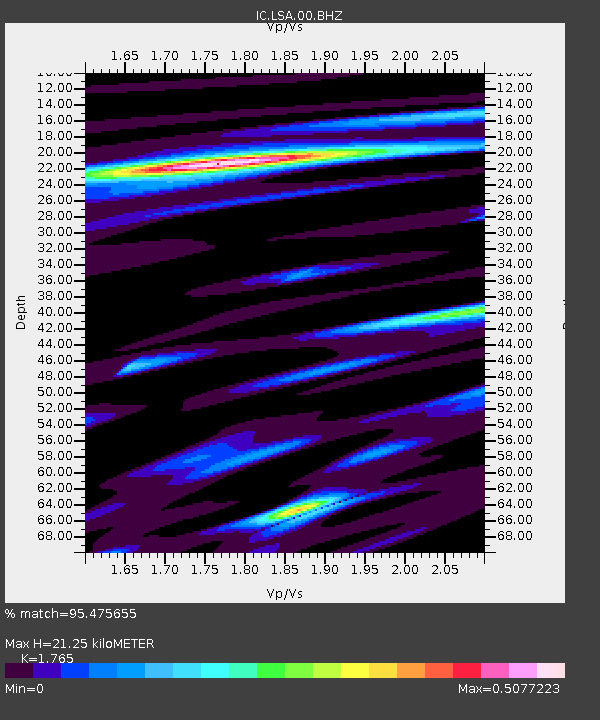
LSA Tibet, China - Earthquake Result Viewer
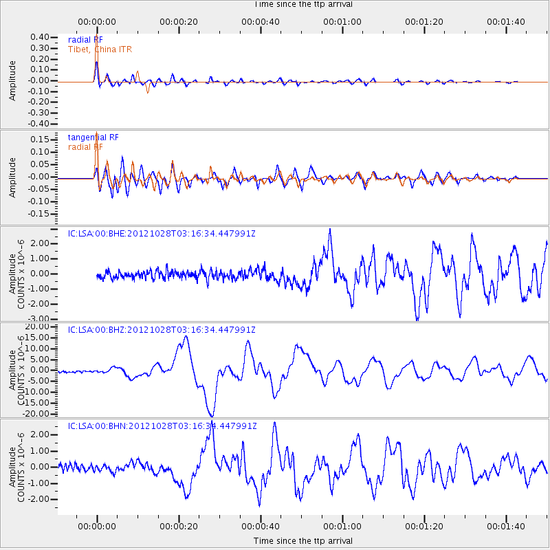
Earthquake location: Queen Charlotte Islands Region
Earthquake latitude/longitude: 52.8/-132.1
Earthquake time(UTC): 2012/10/28 (302) 03:04:08 GMT
Earthquake Depth: 14 km
Earthquake Magnitude: 6.5 MB, 7.5 MS, 7.8 MW, 7.8 MW
Earthquake Catalog/Contributor: WHDF/NEIC
Network: IC New China Digital Seismograph Network
Station: LSA Tibet, China
Lat/Lon: 29.70 N/91.13 E
Elevation: 3660 m
Distance: 89.6 deg
Az: 323.423 deg
Baz: 24.581 deg
Ray Param: 0.041731115
Estimated Moho Depth: 21.25 km
Estimated Crust Vp/Vs: 1.76
Assumed Crust Vp: 6.514 km/s
Estimated Crust Vs: 3.691 km/s
Estimated Crust Poisson's Ratio: 0.26
Radial Match: 95.475655 %
Radial Bump: 400
Transverse Match: 89.29761 %
Transverse Bump: 400
SOD ConfigId: 478790
Insert Time: 2013-03-01 08:22:15.846 +0000
GWidth: 2.5
Max Bumps: 400
Tol: 0.001

Signal To Noise

ChannelStoNSTALTA
IC:LSA:00:BHZ:20121028T03:16:34.447991Z3.88478921.1108164E-62.8593993E-7
IC:LSA:00:BHN:20121028T03:16:34.447991Z1.4854772.0128326E-71.3550076E-7
IC:LSA:00:BHE:20121028T03:16:34.447991Z1.05423642.386629E-72.2638461E-7
Arrivals
Ps2.5 SECOND
PpPs8.8 SECOND
PsPs/PpSs11 SECOND