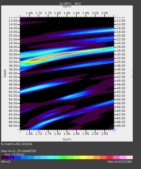
GRFO Grafenberg, Germany - Earthquake Result Viewer
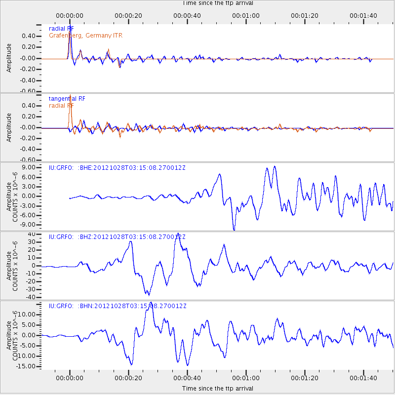
Earthquake location: Queen Charlotte Islands Region
Earthquake latitude/longitude: 52.8/-132.1
Earthquake time(UTC): 2012/10/28 (302) 03:04:08 GMT
Earthquake Depth: 14 km
Earthquake Magnitude: 6.5 MB, 7.5 MS, 7.8 MW, 7.8 MW
Earthquake Catalog/Contributor: WHDF/NEIC
Network: IU Global Seismograph Network (GSN - IRIS/USGS)
Station: GRFO Grafenberg, Germany
Lat/Lon: 49.69 N/11.22 E
Elevation: 384 m
Distance: 73.3 deg
Az: 23.895 deg
Baz: 337.74 deg
Ray Param: 0.05310371
Estimated Moho Depth: 31.25 km
Estimated Crust Vp/Vs: 1.74
Assumed Crust Vp: 6.182 km/s
Estimated Crust Vs: 3.548 km/s
Estimated Crust Poisson's Ratio: 0.25
Radial Match: 98.345634 %
Radial Bump: 400
Transverse Match: 91.80298 %
Transverse Bump: 400
SOD ConfigId: 478790
Insert Time: 2013-03-01 08:22:50.904 +0000
GWidth: 2.5
Max Bumps: 400
Tol: 0.001

Signal To Noise

ChannelStoNSTALTA
IU:GRFO: :BHZ:20121028T03:15:08.270012Z9.7912482.5471938E-62.6015005E-7
IU:GRFO: :BHN:20121028T03:15:08.270012Z3.7198781.0013007E-62.6917567E-7
IU:GRFO: :BHE:20121028T03:15:08.270012Z2.053555.766664E-72.808144E-7
Arrivals
Ps3.9 SECOND
PpPs13 SECOND
PsPs/PpSs17 SECOND