You are here: Home > Network List > G - GEOSCOPE Stations List
> Station WUS Wushi, Xinjiang Uygur, China > Earthquake Result Viewer
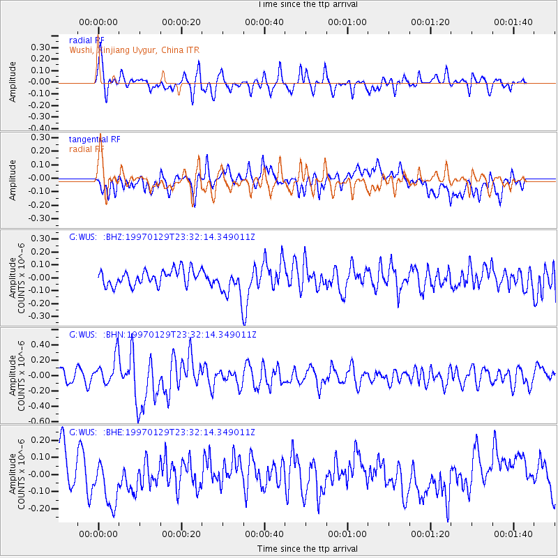
WUS Wushi, Xinjiang Uygur, China - Earthquake Result Viewer
*The percent match for this event was below the threshold and hence no stack was calculated.
| Earthquake location: |
Santa Cruz Islands |
| Earthquake latitude/longitude: |
-12.9/166.4 |
| Earthquake time(UTC): |
1997/01/29 (029) 23:19:20 GMT |
| Earthquake Depth: |
33 km |
| Earthquake Magnitude: |
5.5 MB, 6.0 MS, 6.2 UNKNOWN, 6.0 MW |
| Earthquake Catalog/Contributor: |
WHDF/NEIC |
|
| Network: |
G GEOSCOPE |
| Station: |
WUS Wushi, Xinjiang Uygur, China |
| Lat/Lon: |
41.20 N/79.22 E |
| Elevation: |
1457 m |
|
| Distance: |
96.3 deg |
| Az: |
310.693 deg |
| Baz: |
101.558 deg |
| Ray Param: |
$rayparam |
*The percent match for this event was below the threshold and hence was not used in the summary stack. |
|
| Radial Match: |
68.863335 % |
| Radial Bump: |
400 |
| Transverse Match: |
44.593716 % |
| Transverse Bump: |
400 |
| SOD ConfigId: |
4480 |
| Insert Time: |
2010-02-27 01:07:17.621 +0000 |
| GWidth: |
2.5 |
| Max Bumps: |
400 |
| Tol: |
0.001 |
|
Signal To Noise
| Channel | StoN | STA | LTA |
| G:WUS: :BHN:19970129T23:32:14.349011Z | 2.4335117 | 1.9747979E-7 | 8.1150134E-8 |
| G:WUS: :BHE:19970129T23:32:14.349011Z | 1.4405578 | 1.4174292E-7 | 9.839446E-8 |
| G:WUS: :BHZ:19970129T23:32:14.349011Z | 2.063659 | 1.2167551E-7 | 5.8961056E-8 |
| Arrivals |
| Ps | |
| PpPs | |
| PsPs/PpSs | |


