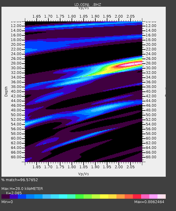
ODNJ Ogdensburg, New Jersey - Earthquake Result Viewer

Earthquake location: Queen Charlotte Islands Region
Earthquake latitude/longitude: 52.8/-132.1
Earthquake time(UTC): 2012/10/28 (302) 03:04:08 GMT
Earthquake Depth: 14 km
Earthquake Magnitude: 6.5 MB, 7.5 MS, 7.8 MW, 7.8 MW
Earthquake Catalog/Contributor: WHDF/NEIC
Network: LD Lamont-Doherty Cooperative Seismographic Network
Station: ODNJ Ogdensburg, New Jersey
Lat/Lon: 41.08 N/74.61 W
Elevation: 187 m
Distance: 39.9 deg
Az: 83.302 deg
Baz: 307.066 deg
Ray Param: 0.074680455
Estimated Moho Depth: 28.0 km
Estimated Crust Vp/Vs: 2.07
Assumed Crust Vp: 6.283 km/s
Estimated Crust Vs: 3.043 km/s
Estimated Crust Poisson's Ratio: 0.35
Radial Match: 96.57652 %
Radial Bump: 246
Transverse Match: 72.80305 %
Transverse Bump: 400
SOD ConfigId: 478790
Insert Time: 2013-03-01 08:25:12.492 +0000
GWidth: 2.5
Max Bumps: 400
Tol: 0.001

Signal To Noise

ChannelStoNSTALTA
LD:ODNJ: :BHZ:20121028T03:11:11.619988Z4.27206132.9887499E-66.996037E-7
LD:ODNJ: :BHN:20121028T03:11:11.619988Z2.13610771.0391791E-64.864825E-7
LD:ODNJ: :BHE:20121028T03:11:11.619988Z3.0530321.6788235E-65.498873E-7
Arrivals
Ps5.0 SECOND
PpPs13 SECOND
PsPs/PpSs18 SECOND