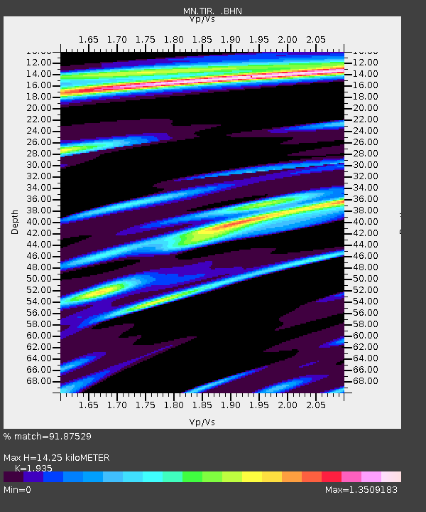
TIR Tirana, Albania - Earthquake Result Viewer
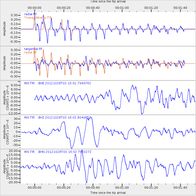
Earthquake location: Queen Charlotte Islands Region
Earthquake latitude/longitude: 52.8/-132.1
Earthquake time(UTC): 2012/10/28 (302) 03:04:08 GMT
Earthquake Depth: 14 km
Earthquake Magnitude: 6.5 MB, 7.5 MS, 7.8 MW, 7.8 MW
Earthquake Catalog/Contributor: WHDF/NEIC
Network: MN MEDNET Project
Station: TIR Tirana, Albania
Lat/Lon: 41.35 N/19.86 E
Elevation: 247 m
Distance: 83.2 deg
Az: 20.881 deg
Baz: 343.291 deg
Ray Param: 0.046383377
Estimated Moho Depth: 14.25 km
Estimated Crust Vp/Vs: 1.93
Assumed Crust Vp: 5.967 km/s
Estimated Crust Vs: 3.084 km/s
Estimated Crust Poisson's Ratio: 0.32
Radial Match: 91.87529 %
Radial Bump: 400
Transverse Match: 86.27313 %
Transverse Bump: 400
SOD ConfigId: 478790
Insert Time: 2013-03-01 08:26:06.956 +0000
GWidth: 2.5
Max Bumps: 400
Tol: 0.001

Signal To Noise

ChannelStoNSTALTA
MN:TIR: :BHZ:20121028T03:16:02.804985Z3.72657444.532082E-61.2161523E-6
MN:TIR: :BHN:20121028T03:16:02.785027Z0.69118748.380562E-71.2124879E-6
MN:TIR: :BHE:20121028T03:16:02.794976Z0.98173311.2225858E-61.2453341E-6
Arrivals
Ps2.3 SECOND
PpPs6.9 SECOND
PsPs/PpSs9.1 SECOND