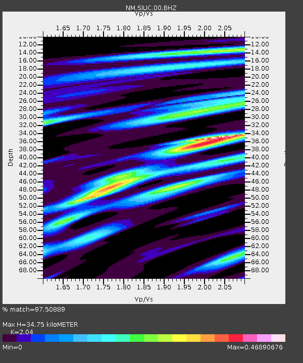
SIUC Carbondale, IL - Earthquake Result Viewer

Earthquake location: Queen Charlotte Islands Region
Earthquake latitude/longitude: 52.8/-132.1
Earthquake time(UTC): 2012/10/28 (302) 03:04:08 GMT
Earthquake Depth: 14 km
Earthquake Magnitude: 6.5 MB, 7.5 MS, 7.8 MW, 7.8 MW
Earthquake Catalog/Contributor: WHDF/NEIC
Network: NM Cooperative New Madrid Seismic Network
Station: SIUC Carbondale, IL
Lat/Lon: 37.71 N/89.22 W
Elevation: 120 m
Distance: 33.2 deg
Az: 99.641 deg
Baz: 310.973 deg
Ray Param: 0.07831349
Estimated Moho Depth: 34.75 km
Estimated Crust Vp/Vs: 2.04
Assumed Crust Vp: 6.444 km/s
Estimated Crust Vs: 3.159 km/s
Estimated Crust Poisson's Ratio: 0.34
Radial Match: 97.50889 %
Radial Bump: 231
Transverse Match: 81.616974 %
Transverse Bump: 400
SOD ConfigId: 478790
Insert Time: 2013-03-01 08:28:26.111 +0000
GWidth: 2.5
Max Bumps: 400
Tol: 0.001

Signal To Noise

ChannelStoNSTALTA
NM:SIUC:00:BHZ:20121028T03:10:14.145012Z4.28080034.198228E-69.80711E-7
NM:SIUC:00:BHN:20121028T03:10:14.145012Z2.96709921.6390776E-65.5241753E-7
NM:SIUC:00:BHE:20121028T03:10:14.145012Z5.47752.2514287E-64.1103218E-7
Arrivals
Ps6.0 SECOND
PpPs15 SECOND
PsPs/PpSs21 SECOND