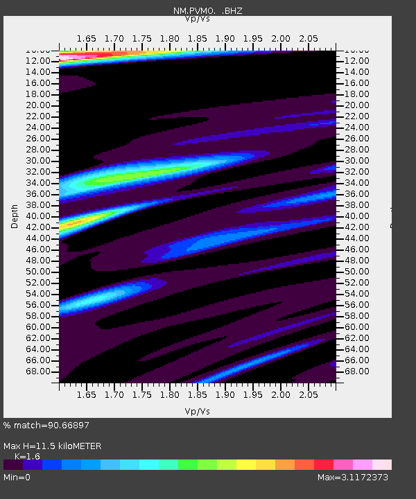
PVMO UM Delta Research Portageville, MO - Earthquake Result Viewer

Earthquake location: Queen Charlotte Islands Region
Earthquake latitude/longitude: 52.8/-132.1
Earthquake time(UTC): 2012/10/28 (302) 03:04:08 GMT
Earthquake Depth: 14 km
Earthquake Magnitude: 6.5 MB, 7.5 MS, 7.8 MW, 7.8 MW
Earthquake Catalog/Contributor: WHDF/NEIC
Network: NM Cooperative New Madrid Seismic Network
Station: PVMO UM Delta Research Portageville, MO
Lat/Lon: 36.41 N/89.70 W
Elevation: 98 m
Distance: 33.8 deg
Az: 101.863 deg
Baz: 312.537 deg
Ray Param: 0.07804778
Estimated Moho Depth: 11.5 km
Estimated Crust Vp/Vs: 1.60
Assumed Crust Vp: 6.444 km/s
Estimated Crust Vs: 4.027 km/s
Estimated Crust Poisson's Ratio: 0.18
Radial Match: 90.66897 %
Radial Bump: 400
Transverse Match: 65.24128 %
Transverse Bump: 400
SOD ConfigId: 478790
Insert Time: 2013-03-01 08:28:38.826 +0000
GWidth: 2.5
Max Bumps: 400
Tol: 0.001

Signal To Noise

ChannelStoNSTALTA
NM:PVMO: :BHZ:20121028T03:10:19.249993Z1.87523322.727127E-61.4542868E-6
NM:PVMO: :BHN:20121028T03:10:19.249993Z0.908430041.3217627E-61.4549968E-6
NM:PVMO: :BHE:20121028T03:10:19.249993Z1.2082232.9173593E-62.4145868E-6
Arrivals
Ps1.2 SECOND
PpPs4.3 SECOND
PsPs/PpSs5.4 SECOND