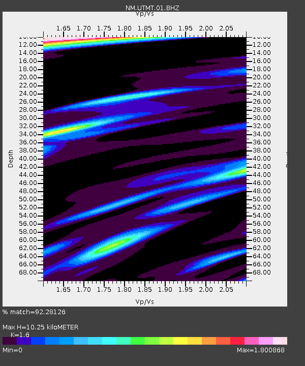
UTMT Martin, TN - Earthquake Result Viewer
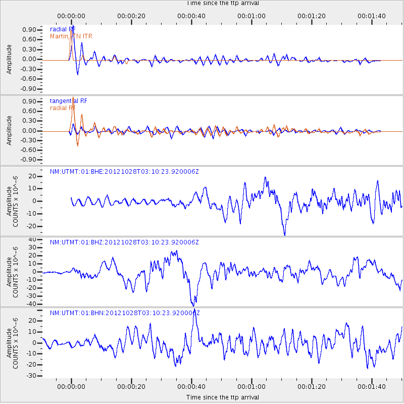
Earthquake location: Queen Charlotte Islands Region
Earthquake latitude/longitude: 52.8/-132.1
Earthquake time(UTC): 2012/10/28 (302) 03:04:08 GMT
Earthquake Depth: 14 km
Earthquake Magnitude: 6.5 MB, 7.5 MS, 7.8 MW, 7.8 MW
Earthquake Catalog/Contributor: WHDF/NEIC
Network: NM Cooperative New Madrid Seismic Network
Station: UTMT Martin, TN
Lat/Lon: 36.35 N/88.86 W
Elevation: 110 m
Distance: 34.3 deg
Az: 101.133 deg
Baz: 312.426 deg
Ray Param: 0.07779883
Estimated Moho Depth: 10.25 km
Estimated Crust Vp/Vs: 1.60
Assumed Crust Vp: 6.444 km/s
Estimated Crust Vs: 4.027 km/s
Estimated Crust Poisson's Ratio: 0.18
Radial Match: 92.28126 %
Radial Bump: 400
Transverse Match: 72.76101 %
Transverse Bump: 400
SOD ConfigId: 478790
Insert Time: 2013-03-01 08:29:04.580 +0000
GWidth: 2.5
Max Bumps: 400
Tol: 0.001

Signal To Noise

ChannelStoNSTALTA
NM:UTMT:01:BHZ:20121028T03:10:23.920006Z2.90647863.339014E-61.1488177E-6
NM:UTMT:01:BHN:20121028T03:10:23.920006Z0.95477112.0518899E-62.149091E-6
NM:UTMT:01:BHE:20121028T03:10:23.920006Z0.94114941.9585323E-62.0810003E-6
Arrivals
Ps1.0 SECOND
PpPs3.8 SECOND
PsPs/PpSs4.8 SECOND