You are here: Home > Network List > G - GEOSCOPE Stations List
> Station WUS Wushi, Xinjiang Uygur, China > Earthquake Result Viewer
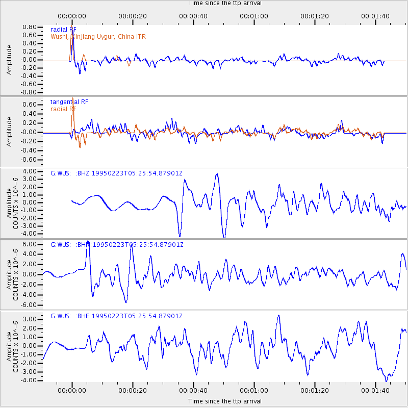
WUS Wushi, Xinjiang Uygur, China - Earthquake Result Viewer
*The percent match for this event was below the threshold and hence no stack was calculated.
| Earthquake location: |
Taiwan |
| Earthquake latitude/longitude: |
24.1/121.6 |
| Earthquake time(UTC): |
1995/02/23 (054) 05:19:02 GMT |
| Earthquake Depth: |
44 km |
| Earthquake Magnitude: |
5.8 MB, 6.2 MS, 6.3 UNKNOWN |
| Earthquake Catalog/Contributor: |
WHDF/NEIC |
|
| Network: |
G GEOSCOPE |
| Station: |
WUS Wushi, Xinjiang Uygur, China |
| Lat/Lon: |
41.20 N/79.22 E |
| Elevation: |
1457 m |
|
| Distance: |
39.1 deg |
| Az: |
306.239 deg |
| Baz: |
102.451 deg |
| Ray Param: |
$rayparam |
*The percent match for this event was below the threshold and hence was not used in the summary stack. |
|
| Radial Match: |
70.653725 % |
| Radial Bump: |
310 |
| Transverse Match: |
62.7716 % |
| Transverse Bump: |
400 |
| SOD ConfigId: |
4480 |
| Insert Time: |
2010-02-27 01:07:42.443 +0000 |
| GWidth: |
2.5 |
| Max Bumps: |
400 |
| Tol: |
0.001 |
|
Signal To Noise
| Channel | StoN | STA | LTA |
| G:WUS: :BHN:19950223T05:25:54.87901Z | 3.253127 | 1.543069E-6 | 4.7433406E-7 |
| G:WUS: :BHE:19950223T05:25:54.87901Z | 0.31296125 | 2.7561546E-7 | 8.8066963E-7 |
| G:WUS: :BHZ:19950223T05:25:54.87901Z | 1.1736672 | 7.051556E-7 | 6.0081396E-7 |
| Arrivals |
| Ps | |
| PpPs | |
| PsPs/PpSs | |


