You are here: Home > Network List > TA - USArray Transportable Network (new EarthScope stations) Stations List
> Station M54A Oil Creek State Park, Oil City, PA, USA > Earthquake Result Viewer
M54A Oil Creek State Park, Oil City, PA, USA - Earthquake Result Viewer
| Earthquake location: |
Queen Charlotte Islands Region |
| Earthquake latitude/longitude: |
52.8/-132.1 |
| Earthquake time(UTC): |
2012/10/28 (302) 03:04:08 GMT |
| Earthquake Depth: |
14 km |
| Earthquake Magnitude: |
6.5 MB, 7.5 MS, 7.8 MW, 7.8 MW |
| Earthquake Catalog/Contributor: |
WHDF/NEIC |
|
| Network: |
TA USArray Transportable Network (new EarthScope stations) |
| Station: |
M54A Oil Creek State Park, Oil City, PA, USA |
| Lat/Lon: |
41.51 N/79.66 W |
| Elevation: |
488 m |
|
| Distance: |
36.6 deg |
| Az: |
86.423 deg |
| Baz: |
306.19 deg |
| Ray Param: |
0.0765713 |
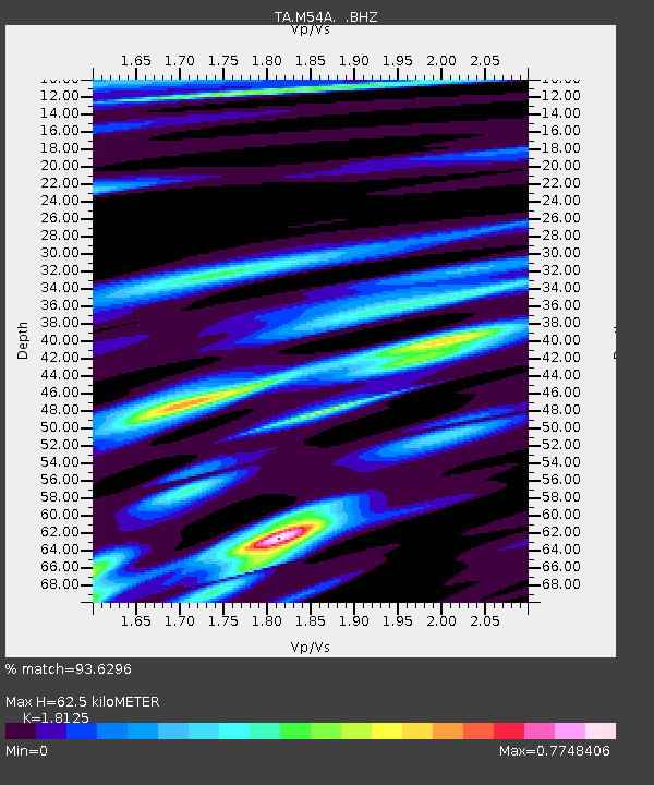
| Estimated Moho Depth: |
62.5 km |
| Estimated Crust Vp/Vs: |
1.81 |
| Assumed Crust Vp: |
6.121 km/s |
| Estimated Crust Vs: |
3.377 km/s |
| Estimated Crust Poisson's Ratio: |
0.28 |
|
| Radial Match: |
93.6296 % |
| Radial Bump: |
223 |
| Transverse Match: |
70.74056 % |
| Transverse Bump: |
400 |
| SOD ConfigId: |
478790 |
| Insert Time: |
2013-03-01 08:32:51.996 +0000 |
| GWidth: |
2.5 |
| Max Bumps: |
400 |
| Tol: |
0.001 |
|
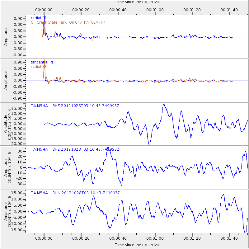
Signal To Noise
| Channel | StoN | STA | LTA |
| TA:M54A: :BHZ:20121028T03:10:43.749993Z | 3.600938 | 3.1621807E-6 | 8.781547E-7 |
| TA:M54A: :BHN:20121028T03:10:43.749993Z | 1.2004749 | 1.0341616E-6 | 8.6146053E-7 |
| TA:M54A: :BHE:20121028T03:10:43.749993Z | 2.0773554 | 1.8384599E-6 | 8.850002E-7 |
| Arrivals |
| Ps | 8.9 SECOND |
| PpPs | 27 SECOND |
| PsPs/PpSs | 36 SECOND |


