You are here: Home > Network List > TA - USArray Transportable Network (new EarthScope stations) Stations List
> Station U39A Green Forest, AR, USA > Earthquake Result Viewer
U39A Green Forest, AR, USA - Earthquake Result Viewer

| Earthquake location: |
Queen Charlotte Islands Region |
| Earthquake latitude/longitude: |
52.8/-132.1 |
| Earthquake time(UTC): |
2012/10/28 (302) 03:04:08 GMT |
| Earthquake Depth: |
14 km |
| Earthquake Magnitude: |
6.5 MB, 7.5 MS, 7.8 MW, 7.8 MW |
| Earthquake Catalog/Contributor: |
WHDF/NEIC |
|
| Network: |
TA USArray Transportable Network (new EarthScope stations) |
| Station: |
U39A Green Forest, AR, USA |
| Lat/Lon: |
36.38 N/93.48 W |
| Elevation: |
433 m |
|
| Distance: |
31.6 deg |
| Az: |
105.765 deg |
| Baz: |
313.589 deg |
| Ray Param: |
0.07901788 |
| Estimated Moho Depth: |
47.5 km |
| Estimated Crust Vp/Vs: |
1.71 |
| Assumed Crust Vp: |
6.53 km/s |
| Estimated Crust Vs: |
3.83 km/s |
| Estimated Crust Poisson's Ratio: |
0.24 |
|
| Radial Match: |
96.44396 % |
| Radial Bump: |
245 |
| Transverse Match: |
85.3471 % |
| Transverse Bump: |
400 |
| SOD ConfigId: |
478790 |
| Insert Time: |
2013-03-01 08:33:30.131 +0000 |
| GWidth: |
2.5 |
| Max Bumps: |
400 |
| Tol: |
0.001 |
|
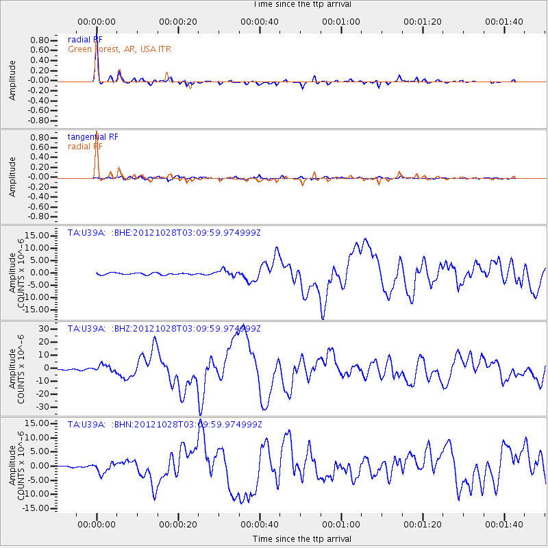
Signal To Noise
| Channel | StoN | STA | LTA |
| TA:U39A: :BHZ:20121028T03:09:59.974999Z | 6.179416 | 2.668781E-6 | 4.318824E-7 |
| TA:U39A: :BHN:20121028T03:09:59.974999Z | 2.3383691 | 1.7690585E-6 | 7.5653514E-7 |
| TA:U39A: :BHE:20121028T03:09:59.974999Z | 3.2484365 | 1.2497372E-6 | 3.847196E-7 |
| Arrivals |
| Ps | 5.6 SECOND |
| PpPs | 18 SECOND |
| PsPs/PpSs | 24 SECOND |


