You are here: Home > Network List > G - GEOSCOPE Stations List
> Station WUS Wushi, Xinjiang Uygur, China > Earthquake Result Viewer
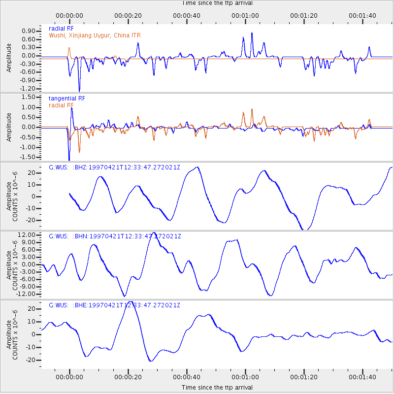
WUS Wushi, Xinjiang Uygur, China - Earthquake Result Viewer
*The percent match for this event was below the threshold and hence no stack was calculated.
| Earthquake location: |
Vanuatu Islands |
| Earthquake latitude/longitude: |
-13.6/166.8 |
| Earthquake time(UTC): |
1997/04/21 (111) 12:20:50 GMT |
| Earthquake Depth: |
33 km |
| Earthquake Magnitude: |
5.7 MB |
| Earthquake Catalog/Contributor: |
WHDF/NEIC |
|
| Network: |
G GEOSCOPE |
| Station: |
WUS Wushi, Xinjiang Uygur, China |
| Lat/Lon: |
41.20 N/79.22 E |
| Elevation: |
1457 m |
|
| Distance: |
97.1 deg |
| Az: |
310.561 deg |
| Baz: |
101.797 deg |
| Ray Param: |
$rayparam |
*The percent match for this event was below the threshold and hence was not used in the summary stack. |
|
| Radial Match: |
70.85003 % |
| Radial Bump: |
264 |
| Transverse Match: |
48.771988 % |
| Transverse Bump: |
400 |
| SOD ConfigId: |
4480 |
| Insert Time: |
2010-02-27 01:07:55.184 +0000 |
| GWidth: |
2.5 |
| Max Bumps: |
400 |
| Tol: |
0.001 |
|
Signal To Noise
| Channel | StoN | STA | LTA |
| G:WUS: :BHN:19970421T12:33:47.272021Z | 1.0622106 | 4.065661E-6 | 3.8275475E-6 |
| G:WUS: :BHE:19970421T12:33:47.272021Z | 1.672821 | 6.9551156E-6 | 4.1577164E-6 |
| G:WUS: :BHZ:19970421T12:33:47.272021Z | 1.664879 | 1.5174779E-5 | 9.114644E-6 |
| Arrivals |
| Ps | |
| PpPs | |
| PsPs/PpSs | |


