You are here: Home > Network List > TA - USArray Transportable Network (new EarthScope stations) Stations List
> Station 143A Socs Landing, Pioneer, LA, USA > Earthquake Result Viewer
143A Socs Landing, Pioneer, LA, USA - Earthquake Result Viewer

| Earthquake location: |
Queen Charlotte Islands Region |
| Earthquake latitude/longitude: |
52.8/-132.1 |
| Earthquake time(UTC): |
2012/10/28 (302) 03:04:08 GMT |
| Earthquake Depth: |
14 km |
| Earthquake Magnitude: |
6.5 MB, 7.5 MS, 7.8 MW, 7.8 MW |
| Earthquake Catalog/Contributor: |
WHDF/NEIC |
|
| Network: |
TA USArray Transportable Network (new EarthScope stations) |
| Station: |
143A Socs Landing, Pioneer, LA, USA |
| Lat/Lon: |
32.70 N/91.40 W |
| Elevation: |
30 m |
|
| Distance: |
35.4 deg |
| Az: |
108.246 deg |
| Baz: |
316.833 deg |
| Ray Param: |
0.0772496 |
| Estimated Moho Depth: |
32.75 km |
| Estimated Crust Vp/Vs: |
1.81 |
| Assumed Crust Vp: |
6.201 km/s |
| Estimated Crust Vs: |
3.436 km/s |
| Estimated Crust Poisson's Ratio: |
0.28 |
|
| Radial Match: |
96.000755 % |
| Radial Bump: |
293 |
| Transverse Match: |
81.114075 % |
| Transverse Bump: |
387 |
| SOD ConfigId: |
478790 |
| Insert Time: |
2013-03-01 08:34:36.957 +0000 |
| GWidth: |
2.5 |
| Max Bumps: |
400 |
| Tol: |
0.001 |
|
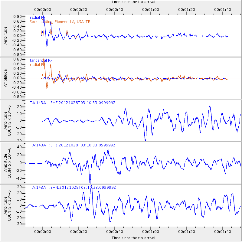
Signal To Noise
| Channel | StoN | STA | LTA |
| TA:143A: :BHZ:20121028T03:10:33.099999Z | 7.6898127 | 4.0785885E-6 | 5.303885E-7 |
| TA:143A: :BHN:20121028T03:10:33.099999Z | 1.721996 | 2.2284978E-6 | 1.2941365E-6 |
| TA:143A: :BHE:20121028T03:10:33.099999Z | 1.1656632 | 2.2774384E-6 | 1.9537704E-6 |
| Arrivals |
| Ps | 4.6 SECOND |
| PpPs | 14 SECOND |
| PsPs/PpSs | 18 SECOND |


